WildCatNL
Posts: 513
Joined: 3/27/2009
From: Eindhoven, the Netherlands
Status: offline

|
(20140823 - Map released)
NTC Central Corridor 199x map for Flashpoint Campaigns: Red Storm
20140823 - 1.0
ntc_central_corridor_199x.zip, 58MB
The above archive contains a map representing the Central Corridor part of the Fort Irwin National Training Center (NTC), California, USA. The map is intended for use with the Flashpoint Campaigns: Red Storm game, 2.04 and later.
No scenarios are included, but you are invited to create them.
NTC
The NTC at Fort Irwin, covering 1000+ square miles, is the US Army's premier large scale maneuver training area. Located in the Mojave desert, the NTC offers barren terrain, wadis, mountains and mountain passes. And desert turtles*.
From its activation the early 80's, the NTC has been the (critical) host for many of the army's new weapon systems (M1 Abrams, M2 Bradley, Stryker) and new fighting concepts.
The following books provide great stories (and analysis) about battles "fought" at the NTC:
- Dan Bolger's "Dragons at War: Land Battle in the Desert" (1986, about rotation 1-83), also published as "Dragons at War: 2-34 Infantry in the Mojave",
available cheaply as 2nd hand pocket and as ebook.
- US Army's A. Frame, J.W. Lussier (eds), "66 Stories of Battle Command" (2000, mainly covering rotations of the 90's),
available from: http://www.au.af.mil/au/awc/awcgate/army/66stories.pdf
Map
The map is huge (93x72 hexes - 40x36km), but the NTC is even bigger. The map covers most of the NTC's width: from Alpine Pass and Crash Hill in the Northwest all the way to the Red Pass in the Southeast. It extends beyond the Central Corridor with enough of the Northern and Southern Corridors to offer alternative routes around and into the Central Corridor.
The map might be too large for older hardware to run it smoothly in the Flashpoint Campaigns - I wasn't able to test this.
The map represents the late 80's and the 90's, before the introduction of the (mock) villages. This to match the 80's order-of-battles of the Red Storm game, and to better cover the stories and maneuvers from the "Dragons at War" and the "66 Stories" books.
The map comes with two map graphics:
- plain: elevation color coded hexes (lighter-is-higher), with a sniff of dust, hill shading and contour lines blended in. Active by default upon installation.
- satellite: as the plain map, but with additional (201x) satellite images mixed in.
The elevation in the plain graphics probably is easier to read. However, the satellite graphics offers more insight into the actual terrain, and may reveal many of the frequently traveled routes if you look carefully. It's your choice.
The yellow borders (dashed lines) rendered on the map indicate barriers to vehicles. The barriers aim to prevent units from driving to the top of a mountain, or up the side of a canyon. The barriers make it critical to control key mountain passes in your maneuvers.
Lacking true barriers in Flashpoint Campaigns 2.0x, I've followed up on the developer's suggestion: terrain on the high side of the barriers is first covered with an invisible stream (at the yellow border) and subsequently by "9" mobility restrictions.
Nevertheless, you are able to place units inside these inaccessible areas when designing scenarios. This might be useful to represent dug-in scout teams. (If you allow the unit to move, they might do so but slowly. And if amphibious the unit might even make it off the mountain).
Production
The map has been created based on actual elevation data and (very incomplete) OpenStreetMap data. Using the QGIS tool, elevation data and OpenStreetMap data were read, manually enhanced with roads and urban areas, and rendered as valid input for the FCRS Map Values tool.
From QGIS, also matching hill shades, contour lines and satellite images were exported.
Using a custom tool the .fp9 map file was rendered as a stack of pancakes, mixing in hill shades, contours and satellite image, and topped off with smoothed roads, location labels, the yellow dashed borders, and a 1km grid overlay.
In a last pass in the FCRS Map Values tool, all 6696 hexes were manually assigned appropriate mobility and visibility/cover ratings, by eye- balling the satellite images for these hexes.
For the sake of gameplay, some elevation values deviate from the actual terrain. Elevation color steps are smaller (more accurate) for lower elevation levels, to better capture those parts of the terrain that are accessible to units.
I've also created a set of sunken hexes in the Washboard section to represent the cover (wadis) available there.
Not having visited NTC myself, I'm counting on those members in our community who experienced the NTC to offer corrections.
Revision History
1.0 Initial version (20140823)
Known issues:
- Fort Irwin's urban area covers too much terrain, especially in an '80s setting. I could solve it by rescanning the terrain, but that would reset 6696 visibility values and wipe the road network. Maybe later...
- Desert turtles not included.
Enjoy!
William

 Attachment (1) Attachment (1)
< Message edited by W1ll14m -- 8/23/2014 9:31:26 PM >
_____________________________
William
On Target Simulations LLC
|
 Printable Version
 new map: NTC Ft. Irwin -
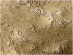


 New Messages
 No New Messages
 Hot Topic w/ New Messages
 Hot Topic w/o New Messages
 Locked w/ New Messages
 Locked w/o New Messages
 Post New Thread