Daniele
Posts: 1812
Joined: 2/7/2015
Status: offline

|
Hello, my name is Dmitriy Maksimov and I am creating maps and an interface for the game Armored Brigade. For the past 10 years I have professionally practiced graphic design, illustrations and visualizations in quite a variety of ways, but mostly in the digital sphere.
The task for drawing maps seemed to me extremely interesting and curious, because it affects a huge layer of information design, which is very important and interesting in a wargame.
The genre of strategy has always been a complex genre, but the wargames, I think, bring this genre to the highest level of uniqueness and exactingness. Their unusualness lies in almost every detail of the game. Fans, and even just wargame-lovers, as a rule are very demanding people - they know many historical nuances, details and subtleties and are able to operate them.
Such a nuance makes huge demands on the game, but at the same time it sets a certain challenge for creating a really interesting product.
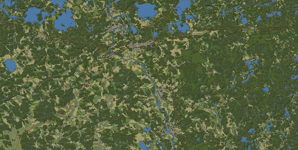
In my case, these challenges are maps. At the moment the game touches the years of 1965-1991, and the battlefield is Finland and Germany, the confrontation between NATO and the PACT.
The classic story of the Cold War becomes hot. And in this period the maps are not less interesting (they are always interesting). The creation of maps is based on the original sources of information. As a rule, they are scattered and not systematized.
The search for any necessary information is akin to fishing: you never know where and when you will find the information you need, in sufficient quantity, especially with time, you come across more detailed information and have to make changes, but the game allows you to do this without any difficulties.
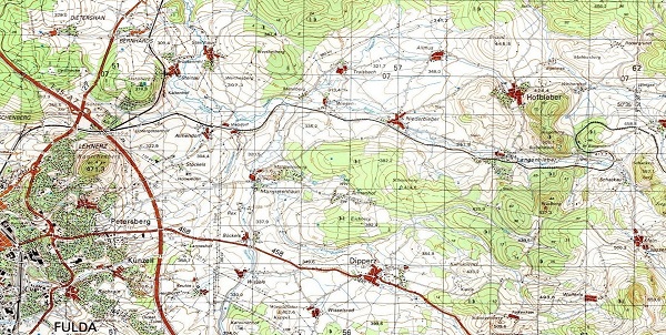
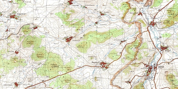
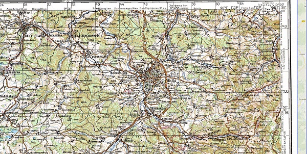
Since that time, less than half a century has passed, so in the internet and other sources you can still find information, maps, photos from those places. To a greater extent, I was using Soviet military maps of that period (they can be found on different sites on the web), and knowledge of the Russian language and map symbols allowed me to navigate with ease.
Since that time, not much has changed, so it is possible to base the work on current maps, but it is necessary to monitor the changes. More precisely, to check what is shown on modern maps but did not exist in the 80s, and what existed in the 80s but is not shown on modern maps.
For example, the Fulda-Kassel high-speed railroad in 1987 was not yet built, and the old Rhönbahn section of the Fulda-Gersfeld railroad has been turned into a bicycle path. E18 highway in the south of Finland did not yet exist, and highway 27 west of Hünfeld went a little differently.
The world map changes every day, cities are built up, the roads are laid new ways, the railways are dismantled, houses are demolished and new ones built – each map is filled with such small details that convey the spirit of the times and create a difference between for example 1950 and 1980. Of course, not everything can be seized and something unavoidably will be missed, but I try to find such differences when checking different sources.
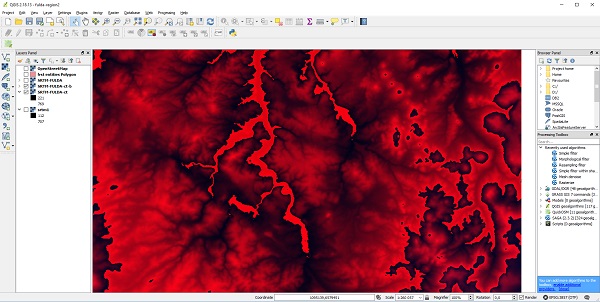
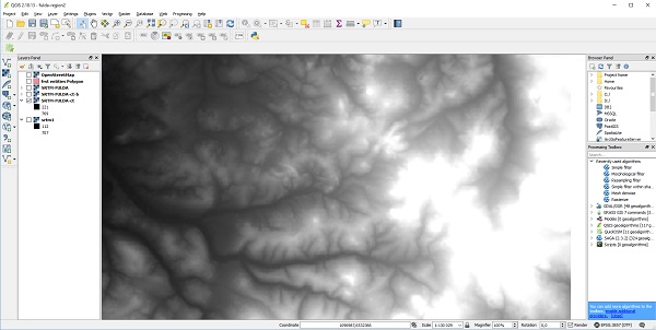
An important point in creating a map is creating the right terrain for the map. There are several ways where you can find a height map of almost any part of the Earth and some countries even officially distribute altitude maps (by the example of Finland).
In any case, it is important to observe the scale and correctly interpret the height map. It must be combined with a real map and use the correct projections: in different wargames from time to time there are noticeable errors in the projections of maps and then the distances are not entirely accurate.
However, this does not affect the mechanics of the game at all, but rather the question of authenticity. Knowing this and using professional software to interpret and display elevation maps, you can solve this problem, but still there are difficulties from time to time.

I import some of the data straight from OpenStreetMaps, but I mostly have to go through the map manually. The game has a specific system of tiles and rendering of roads, buildings, rivers, lakes, forests and much much more.
It's just that you do not digitize the data, but over time I have developed a large number of techniques, which greatly facilitated the creation of map objects.
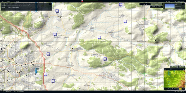
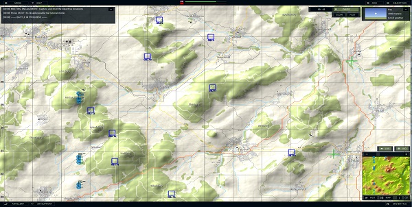
I also should mention the internal map editor, made by our leader and the only programmer of the project - Juha. The interface of the map editor is not polished yet, but rather for internal use, but thanks to it the creation of maps for this game became more like a classic urban planning simulator.
You draw roads, houses, forests, rivers, lakes - the main thing is to adhere to real data, and the conditions of the landscape rendering system in the game, and everything will turn out fine.
It seems to me that in wargames (at least in our game) there is a big difference between the level design and how it relates to real life.In ordinary games, the level-designer first of all tries to make the map more interesting, and he as an artist painting all its details with the calculation of how it would be interesting to fight on this map: how to hide a platoon of recon units between these trees, and then place a hill to open the view on the battlefield for means of Anti-Air units.
In our game (as well as in some other wargames) we tried to adhere to a realistic landscape: if there is a forest with a footpath on a hill in real life, then in the game it should be the same. Of course, “the game” is primarily entertainment, but in our case we wanted to find interesting real world locations for fighting fascinating battles.
That is, we took the opposite approach: we are looking for interesting reality rather than trying to create an alternate reality.
For an enthusiastic person, the process of creating any kind of maps brings new sensations towards the created territory. It becomes something native, you know where the roads go and what shape this lake is, you get used to the arrangement of details.
As if you live in this place, and when you look at the pictures from the region, there is a certain feeling of intimacy, as if you were here a long time ago. I think all cartographers have such a feeling and it does not matter if he draws maps for a game or draws for real life.
After all, a similar feeling arises among all players: you playing dozens of hours in the game on the maps that have been created by someone and then, after a while, you return to the game, and because all that time spent playing in the past, it feels so familiar, and the feeling is just like of someone who created this map and spent the same tens and hundreds of hours as you played it.
Strange feeling, indeed.
< Message edited by Daniele -- 2/4/2019 10:15:19 AM >
|
 Printable Version
 The Art of Making Maps -
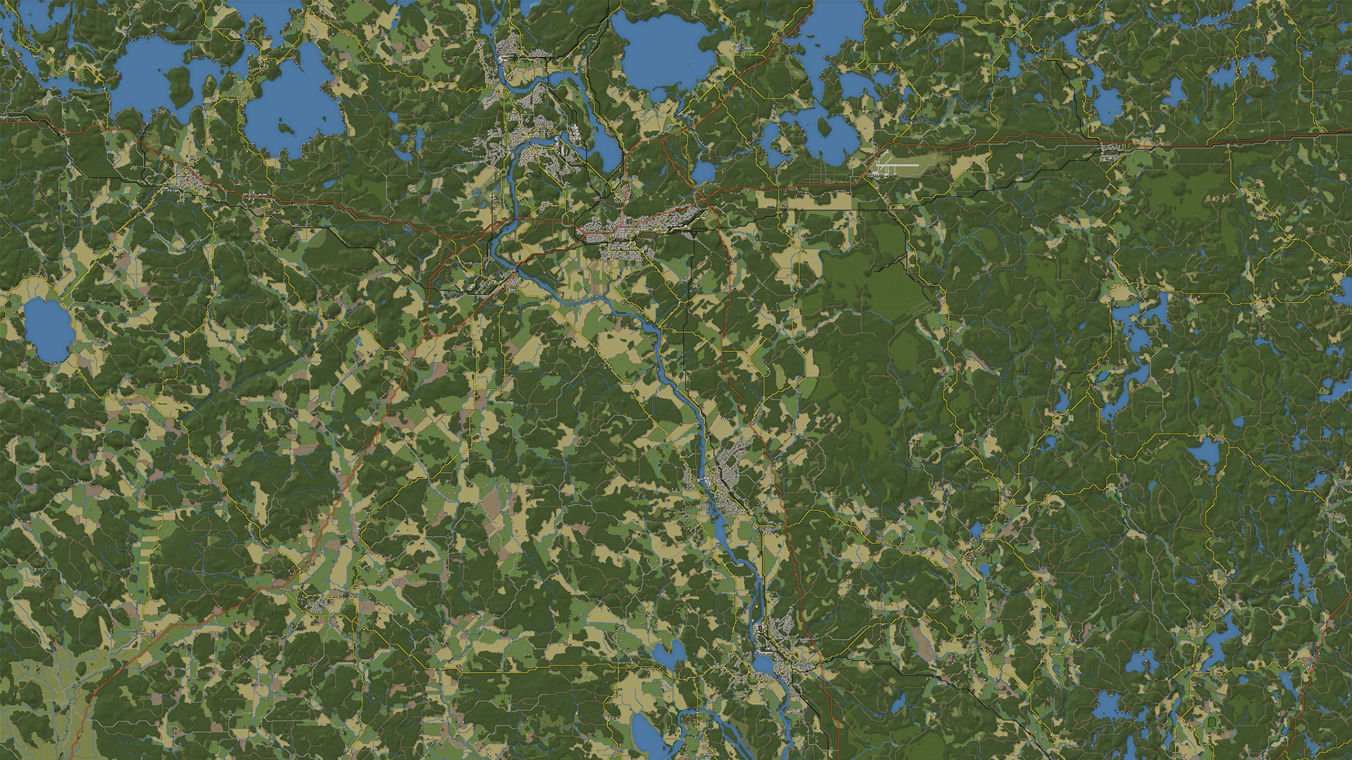


 New Messages
 No New Messages
 Hot Topic w/ New Messages
 Hot Topic w/o New Messages
 Locked w/ New Messages
 Locked w/o New Messages
 Post New Thread