Stimpak
Posts: 632
Joined: 8/23/2015
From: BC, Canada
Status: offline

|
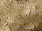
Ladies and Gentlemen, I present to you FCRS_Nienburg:

From Wikipedia:
Nienburg (official name: Nienburg/Weser) (Low German: Nienborg, Neenborg or Negenborg) is a town and capital of the district Nienburg, in Lower Saxony, Germany.
-Geography-
Situated on the scenic German Timber-Frame Road, Nienburg lies on the river Weser, approximately 55 km (34 mi) southeast of Bremen, and 45 km (28 mi) northwest of Hanover. Nienburg is the largest town in the Middle Weser Region. There are many bridges in the area, making it a likely axis of advance for Warsaw Pact forces should a Weser River crossing be denied elsewhere. This includes the application of air assault units, either to support an advance, or to serve as a decoy.
The local topography is relatively flat, but the area is significantly forested and urbanized, leaving some areas with short engagement areas, but still providing plenty of clearings for long range engagements.
-History-
Nienburg saw relatively little action in WW2 and was mostly a home to Oflag X-B, a POW camp for captured enemy officers, 1000 of which were Polish. Later on British, Serbs, Romanians, and Soviet prisoners were also interred here. Nienburg was home to the Wehrmacht 22nd Pioneer battalion of the 22nd Infantry Division, but this unit spent the war at the Siegfried line.
The only notable combat action here was the accidental bombing of one of the POW camps by a stricken British Lancaster bomber; 98 prisoners were killed and several huts were destroyed when flak forced the aircraft to jettison it's bombs. The railway bridge located on the map was also a target of the massive "Grand Slam" bomb employed by allied aircraft.
Later on in April 9, 1945, the British army marched into Nienburg seemingly without a fight, liberating the prisoners held there. Afterward, the camps were re-purposed to house war refugees. The former Oflag was taken over by the British Army of the Rhine and renamed "Assaye Barracks". It was the base of the 21st Regiment, Royal Engineers, from 1950 to 1996, and also of the 24th Missile Regiment, Royal Artillery from 1959 to 1962, operating the MGR-1 Honest John nuclear surface-to-surface missile. It does not appear that a unit operating the MGM-52 Lance ever replaced them. The British army left Nienburg in 1996 and Assaye Barracks was demolished.
More noteworthy is the Clauswitz-Kaserne in Langendamm, southeast of Nienburg. This barracks was large and home to nearly the entirety of Panzerbrigade 3, of 1st Panzerdivision. The only units of the Brigade not stationed here were Panzerbatailon 33, and Panzerartileriebatailon 35, which instead were stationed in the small village of Luttmersen, 22 kilometers east. Either barracks would be likely victims of Soviet nuclear, chemical, air, and artillery strikes.
It seems likely that this unit would have been engaged west of Celle and north of Hanover in the event of a Soviet attack, covering the south flank of Panzerlehrbrigade 9, of 3rd Panzerdivision. A surprise Soviet attack however could force them to fight for their own hometown at the Weser crossing in Nienburg.
-Warsaw Pact Forces-
Likely units attacking here would be units from the 5. Armee of the NVA, and 3rd Combined Arms Army.
Possible divisions from the East Germans as of 1983 were 19. MSD, 1. MSD, and the elite 9. PzD. If the other divisions, 8. MSD and 20. MSD failed in their advance while 19. MSD broke through, then 9. PzD would cross the Weser here and attack deeper into the I BR Corps area.
Possible divisions from the Soviets include 47th Guards Tank Division armed with T-64s, 10th Guards Tank Division with T-80s. These were high-readiness units with good equipment, and thus likely fielding their BV variants.
fcrs_Nienburg and it's .fp9 file are now available for download - as the files are too large to be uploaded here, you can instead find them on my Google Drive here:
https://drive.google.com/file/d/0B8eT5mRv4zicN08wTDl2Y0hSdE0/view?usp=sharing
To install, simply drop both files into your Modules/FPRS/Maps folder.
|
 Printable Version
 RE: Stimpak's New Maps -


 New Messages
 No New Messages
 Hot Topic w/ New Messages
 Hot Topic w/o New Messages
 Locked w/ New Messages
 Locked w/o New Messages
 Post New Thread