TheOttoman
Posts: 139
Joined: 12/14/2017
Status: offline

|
In doing research on some Desert Shield scenarios that I am working on, I came across a trove of U-2/TR-1 information and I believe that I've uncovered some inconsistencies with the platform. This post is to provide discussion before an actual request for changes to the database. Throughout this post, I will use the term “U-2R” to represent both the TR-1A and U-2R, as the platforms are effectively identical, and that the TR-1A represent the planes that were assigned to the 17th Reconnaissance Wing, headquartered in RAF Alconbury.
The database contains the following platforms:
2153 - TR-1A Dragon Lady (United States - 1984)
1076 - TR-1A Dragon Lady (United States - 1987-1991)
2152 - U-2R (United States - 1968)
817 - U-2R (United States - 1987)
821 - U-2S (United States - 1995)
2919 - U-2S (United States - 2002)
2096 - U-2S (United States - 2005)
2918 - U-2S (United States - 2013)
For the purposes of this discussion, we will not be talking about platform 2152, the U-2R from 1968
GENERAL DATA
All of the data across the different platforms appears to be correct and without issue.
SENSORS / EW
These entries have the potential for the most change due to how the U-2R is configured. Unlike traditional platforms, the individual sensor package is tied to an airframe, meaning that depending on the mission, a sensor is chosen to fulfill a mission requirement, and then that sensor is married to a specific airframe. Due to the limited inventory of sensors, in some cases there is only one or two of a type of sensor, not all airframes have been modified to carry a specific sensor package. For example, airframe #80-1070 may be configured to accept both the ASARS sensor and the IRIS-III imagery sensor, but airframe #80-1071 may be configured to accept only the ASARS sensor, and a third airframe #80-1072 may be configured to only accept HR-329 camera only and no other sensor package. In the real world this airframe and sensor knowledge is/was a deficiency to the USAF, and this knowledge is maintained by Lockheed contractors. That is why Lockheed contractors will often deploy with the U-2. The sensor packages available to the U-2R are as follows:
• SENIOR BOOK A communications intelligence [COMINT] package used between the 1970’s -80’s specifically created to monitor Chinese communications. Range is unknown
• SENIOR GLASS Before 1996/97, the SENIOR SPEAR, and SENIOR RUBY modules were separate and not linked. SENIOR GLASS is the combination of SENIOR SPEAR and SENIOR RUBY packages into a single module (the right and left underwing pods), along with a vertical antenna farm on the belly of the aircraft.
• SENIOR LANCE Goodyear SAR radar mounted in the Q-Bay Payload. The SAR provided resolutions from 5-foot to 1-foot. Mounted on one or two airframes. 1970’s. Never operationally deployed
• SENIOR OPEN a rotating LOROP (LOng-range Oblique Photographic) camera nose system. Repurposed into SENIOR YEAR.
• SENIOR RUBY an electronics intelligence and signals intelligence package in the right underwing pod. This was further integrated into SENIOR GLASS
SENIOR SPAN this is a satellite link mounted on the top of the aircraft in a teardrop shaped dorsal module, and also in the nose cone of the aircraft. After 1996/7 this package was created to remove the need for a SENIOR BLADE / TRAC station. This allows for transmission of SYERS and ASARS data to be transmitted at ranges greater than 220 miles.
• SENIOR SPEAR is a communications intelligence [COMINT] package that monitors battlefield communications. This package is mounted under the wings in the left pods.
SENIOR SPUR a Beyond Line of Sight data link package. Like SENIOR SPAN, this is mounted on the top of the aircraft in a teardrop shaped dorsal module. After 1996/7 this package was created to remove the need for a SENIOR BLADE / TRAC station. This allows for transmission of SYERS and ASARS data to be transmitted at ranges greater than 220 miles. It is believed that this uses a Ku band satellite datalink to disseminate data as a battlefield relay surrogate.
• SENIOR YEAR the full name is SENIOR YEAR Electro-optical Reconnaissance System (SYERS). This is a dual band electro-optical imagery sensor and infrared sensor. The SENIOR YEAR module had the ability to provide near real time imagery to a ground station (SENIOR BLADE) up to a range of 220 mile. If the U-2R moves outside of the 220 mile range of the SENIOR BLADE station, imagery would be stored on the plane until contact was re-established. A hard copy of the imagery would be available within about 20 minutes of reception in the SENIOR BLADE station. SYERS could only operate in Day / Clear Weather. Deployed 1990+
• ASARS-1/2 Advanced Synthetic Aperture Radar System. Unlike SYERS, ASARS could operate in Day/Night/ All Weather conditions. Much like SYERS, it was able to transmit at near real time speed down to an Army Tactical Radar Correlator (TRAC) station. It had a similar range (220 mi) as SYERS. This is the same radar system that was mounted on the SR-71. ASARS-2 was used extensively during Operation Desert Storm (1991). Its capabilities are a similar, though less powerful version of the E-8 J-STARS program.
• ASARS-2A Upgraded synthetic aperture radar system. Entered service 2001
• PLSS Precision Location & Strike System. This is an electronic intelligence [ELINT] package built to locate specific Warsaw Pact radars and missile sites that are threats to the U-2R. Meant to be used with three U-2R aircraft, each plane would fly in a race-track pattern and triangulate emissions from WP radar and missile sites. Program was cancelled in 1987 without deployment.
This list in not inclusive of all of the other packages that can be mounted in the U-2R including various cameras and sensors. For the purposes of Command, the majority of the U-2Rs that can be deployed will be either a form of the SENIOR YEAR, or ASARS/ASARS-2 configuration. Platform #821 (U-2S United States [Air Force], 1995) lists both of these sensors as deployed. With a range of 100nm. Since both the SYERS and ASARS packages reside in the nose payload, it would make sense they cannot both be part of that platform. However, speaking to the uniqueness and “one-off” of the platform the USAF has made an effort to merge both SYERS and ASARS-2A into a single payload. There is visual representation of a single airframe with both SYERS and ASARS-2 *and* a SENIOR SPAN or SENIOR SPUR module all together. Additionally, prior to the deployment of SENIOR SPAN / SENIOR SPUR, real time imagery would only be possible if there was a datalink back to a SENIOR BLADE/TRAC station (< 220 miles). I’m not sure how that could be modeled in Command so that the U-2 flies over an area outside of the 220 mile radius.
MOUNTS / STORES / WEAPONS
According to Janes All The World’s Aircraft 1986-87, maximum range is listed as 2,605nm / 4,830km / 3,000mi
According to Air Force Military Fact Sheet (http://www.af.mil/About-Us/Fact-Sheets/Display/Article/104560/u-2stu-2s/) Range is listed as 6,090nm / km / > 7,000mi. This could be meant for U-2S and not the U-2R
Typical missions lasted 10-12 hours
COMMS/DATALINKS
All entries list a COMMS/DATALINKS package for both AFSATCOM and Skynet SATCOM. I can find no information listing either one of these packages present. Additionally, while AFSATCOM and the U-2R are Strategic Air Command (SAC) platforms, AFSATCOMs primary use is for National Military Command Centers (NMCC and ANMCC) to connect directly to US strategic nuclear forces. It is obvious that the U-2R is not part of the US Strategic Nuclear Forces. Skynet SATCOM is used by the UK. It is not believable that SAC would allow the UK Ministry of Defense (MoD) to have direct communication to a U-2R pilot through encrypted satellite. I would recommend the deletion of both of these packages from all platforms.
All I have been able to find in terms of avionics is HF, UHF, and VHF communications radios, along with INS, Tacan, ILS, autopilot, ADF, air data computer, a compass and an astro-compass (for night flying). All avionics are stored in a detachable nose section.
There are various datalinks including the SENIOR SPUR Link, Interoperable Data Link and the Dual Data Link that need to be added to the database
PROPERTIES
All platforms list Boom Refueling, and while there are a couple of airframes that have been converted to handle Air to Air Boom refueling, these were more experimental and not operational. Boom Refueling should be removed.
Night Navigation and Fuselage Structure should remain in place
PROPULSION
J57-P-37A: Found in U-2A, U-2E
J75-P-13B #1: Found in U-2C, U-2F, TR-1A, TR-1B, and ER-2 airframes
F118-GE-101 #1 Found in U-2S airframes starting 1995. All airframes converted by 1999
All three types of engines are Turbojects and all have a max speed of about 410-430 kts.
FUEL
The U-2R platform does not use the same “Aviation Fuel” as typical aircraft. I am not sure how this can be modeled in Command, nor do I know how difficult it would be to create a new type of fuel type specific to the U-2R.
NOTES
Unlike many of the typical aircraft platforms, the U-2R is considered a “national strategic asset” meaning up until recently (~2001) the platform was not able to provide true “real time” data down to the warfighter. Due to its assignment to SAC instead of the USAF directly, all missions are normally planned in advance and follow specific tracks avoiding all known radars and missiles in the possible flight path. To further illustrate the process of on the use of the U-2 platform consider the following:
After the shoot down of Gary Powers in 1960, a set of procedures were developed on the authorization and use of the U-2 during peacetime. If a theater CINC wanted intelligence gathered from the U-2R he needed to get approval from the National Command Authority (NCA). The theater CINC would direct his request to the Pentagon’s Joint Reconnaissance Center. There, the center would analyze the request to find out if Air Force assets were already covering the target area, and if the request was appropriate for the U-2. If satisfied, the Center would then coordinate with the Defense Intelligence Agency (DIA) to ensure there was no redundant coverage by sources outside of the Air Force. If DIA approved the request, the Joint Reconnaissance Center then took the request through the Chain of Command up through the Joint Chiefs of Staff, the Secretary of Defense and the president’s national security advisor, who has the ability to approve the request in the name of the President. This part of the process takes about two weeks to accomplish. Once NCA approval is secured, the Joint Reconnaissance Center then sent the request to the Strategic Reconnaissance Center at Offutt AFB (SRC). SRC then made evaluations on all threats to the aircraft, coordinated the movement of the aircraft in cases where the target is outside of the bed down range, along with the movement of sensors and staff and equipment, and then scheduled the sortie SRC then sent the sortie to the Wing, where the mission planners prepared the actual flight track and briefed the pilot. If the mission was flown during peacetime, the pilot flew under Peacetime Applications of Reconnaissance Program (PARPRO) rules. PARPRO flights always were in international or friendly airspace. The plane was flown under VFR conditions, performed regular radio checks and avoided all threats. If for any reasons the pilot could not operate under PARPRO rules, the mission was aborted and RTB.
At the conclusion of the mission, any photography would be sent to the theater photography processing element for analysis. If there was none in theater, then it could take up to a week after the mission was flown before the theater commander could receive the photographs he requested, possibly three weeks from his initial request. To help reduce the time to deliver intelligence, commanders opted to forgo cameras and use electro-optical or radar imagery like SENIOR YEAR or ASARS which provided near real time results if ground stations were in place. It is important to note that during the Cold War and after the DESERT STORM era, these ground stations were almost exclusively in the European theater.
Only in cases of active hostilities, like DESERT STORM, does SAC consider transferring operating control of the U-2R to USAF Combat Commanders (CENTAF, PACAF,EURAF, etc.). DESERT STORM showed the potential for the U-2 to be used in tactical theater operations, however the platform still was a strategic asset operating in a semi-tactical capacity. To overcome this, the SENIOR SPEAR and SENIOR SPAN modules were developed to provide OTH datalinks. However it wasn’t until the late 90’s before these projects were fully deployed. It is assumed that the real-time capabilities are relatively new (> 2001) where imagery can be transmitted to any point on the Earth down to the individual war-fighter, or to a fighter pilot’s mission briefing.
< Message edited by TheOttoman -- 6/5/2018 8:54:58 PM >
|
 Printable Version
 U-2 Discussion / Use of U-2 in scenarios -


 to post links yet
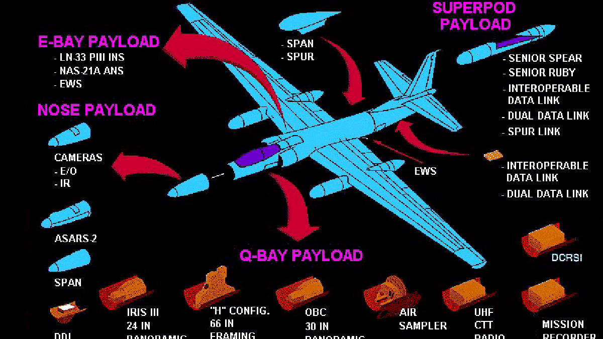
 New Messages
 No New Messages
 Hot Topic w/ New Messages
 Hot Topic w/o New Messages
 Locked w/ New Messages
 Locked w/o New Messages
 Post New Thread