Matrix Games Forums

Forums  Register  Login  Photo Gallery  Member List  Search  Calendars  FAQ 

My Profile  Inbox  Address Book  My Subscription  My Forums  Log Out

RE: Solomon Islands Map

 
View related threads: (in this forum | in all forums)

Logged in as: Guest
Users viewing this topic: none
  Printable Version
All Forums >> [New Releases from Matrix Games] >> World in Flames >> RE: Solomon Islands Map Page: <<   < prev  3 4 5 6 [7]
Login
Message << Older Topic   Newer Topic >>
RE: Solomon Islands Map - 4/1/2008 11:13:09 PM   
Froonp


Posts: 7995
Joined: 10/21/2003
From: Marseilles, France
Status: offline
quote:

ORIGINAL: Shannon V. OKeets

Sigh, once again I lose an 'argument' to a person who actually knows what he is talking about. Stupids facts!

I'll just go back to working on my code.

Normaly, I prefer to stay minimalistic as of the changes from CWiF, and even more for the changes from WiF FE.
But here, they are really changes for the better, there are absolutely no reasons not to change. It is more accurate on both the geographical / administrative and historical simulation.

I was interested by Marcus remark, I researched and saw he was right, so now I support the change.

(in reply to Shannon V. OKeets)
Post #: 181
RE: Solomon Islands Map - 4/1/2008 11:17:12 PM   
Froonp


Posts: 7995
Joined: 10/21/2003
From: Marseilles, France
Status: offline
quote:

ORIGINAL: Norman42
Creating the above 3 territories is a rather elegant solution to make both gaming the conquests less tedious, and more historical at the same time.

3 ?

I propose 2 where there were 4 initialy.
There were :
- Admiralty Islands.
- New Britain.
- Papua.
- New Ireland.

I propose they become :
- Territory of New Guinea (containing northeast Papua, Admiralty Islands, New Britain, New Ireland and Bougainville).
- Papua (same as it is, with the northeast part becomeing Territory of New Guinea).

(in reply to Norman42)
Post #: 182
RE: Solomon Islands Map - 4/1/2008 11:43:07 PM   
Shannon V. OKeets


Posts: 22095
Joined: 5/19/2005
From: Honolulu, Hawaii
Status: offline

quote:

ORIGINAL: Froonp

quote:

ORIGINAL: Norman42
Creating the above 3 territories is a rather elegant solution to make both gaming the conquests less tedious, and more historical at the same time.

3 ?

I propose 2 where there were 4 initialy.
There were :
- Admiralty Islands.
- New Britain.
- Papua.
- New Ireland.

I propose they become :
- Territory of New Guinea (containing northeast Papua, Admiralty Islands, New Britain, New Ireland and Bougainville).
- Papua (same as it is, with the northeast part becomeing Territory of New Guinea).


I believe he meant combining the 3 teritories into 1.

_____________________________

Steve

Perfection is an elusive goal.

(in reply to Froonp)
Post #: 183
RE: Solomon Islands Map - 4/1/2008 11:44:56 PM   
Norman42


Posts: 244
Joined: 2/9/2008
From: Canada
Status: offline
I was under the impression that it would be

-New Guinea (mainland only)
-Bismarck Archipelago (the isles you stated)
-Papua (as it is)

Either way, 2 or 3 is fine, its the avoidance of having to occupy every single hex that I think is key.  The occupation of the strategic sites will conquer all 3 (or 2) territories.

_____________________________

-------------

C.L.Norman

(in reply to Froonp)
Post #: 184
RE: Solomon Islands Map - 4/1/2008 11:51:18 PM   
Froonp


Posts: 7995
Joined: 10/21/2003
From: Marseilles, France
Status: offline
quote:

ORIGINAL: Norman42

I was under the impression that it would be

-New Guinea (mainland only)
-Bismarck Archipelago (the isles you stated)
-Papua (as it is)

Either way, 2 or 3 is fine, its the avoidance of having to occupy every single hex that I think is key.  The occupation of the strategic sites will conquer all 3 (or 2) territories.

This would have been good too, but The Territory of New Guinea also comprised the Bismarck Archipelago.

(in reply to Norman42)
Post #: 185
RE: Solomon Islands Map - 4/4/2008 3:08:21 PM   
marcuswatney


Posts: 279
Joined: 2/28/2006
Status: offline
I have been off-line for some time, giving my children a holiday in the country, which is why I have not been involved in this discussion recently.

I support Patrice's proposal.  Indeed, it was what I originally suggested.  At the time, I accepted Patrice's counter-proposal to create three territories (Papua, NE New Guinea, the islands) because I saw that as an acceptable compromise.  But I do prefer Patrice's present proposal, as it is historically accurate and functional (following the 1937 eruption that devastated Rabaul, the capital was moved to Lae).

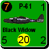
It is worth noting that the geographically-peculiar attachment of Bougainville to the Territory of New Guinea instead of to the Solomon Islands continues to cause problems.  Because of this ancient League of Nations Mandate, today Bougainville is part of Papua New Guinea, not the Solomons to which the inhabitants feel ethnically connected.  Rapacious mining operations have exacerbated problems on the island to the extent that there is an on-off civil war there that flares up from time to time.

Incidentally, Patrice please remember my earlier recomendation that two alpine hexsides be shifted when creating the border between Papua and NE New Guinea.  In fact you might do well to reconsider how the entire mountain spine is depicted on the map, since it is now going to be more significant.

< Message edited by marcuswatney -- 4/4/2008 3:10:51 PM >

(in reply to Froonp)
Post #: 186
RE: Solomon Islands Map - 4/4/2008 8:40:58 PM   
Froonp


Posts: 7995
Joined: 10/21/2003
From: Marseilles, France
Status: offline
quote:

ORIGINAL: marcuswatney
Incidentally, Patrice please remember my earlier recomendation that two alpine hexsides be shifted when creating the border between Papua and NE New Guinea.  In fact you might do well to reconsider how the entire mountain spine is depicted on the map, since it is now going to be more significant.

Yes, I remember, but I prefered to keep it as it is already, only placing the borders. I prefer the map changes be minimalistic, and assuming the mountains have been done correctly, I don't want to change them because I'm adding the new border. I believe I can add the border without changing the mountains.

(in reply to marcuswatney)
Post #: 187
RE: Solomon Islands Map - 4/4/2008 9:14:57 PM   
marcuswatney


Posts: 279
Joined: 2/28/2006
Status: offline
Patrice, I will be very impressed if you can do that!  The excellent map you provided in Post 158 shows that the border runs south of the mountain spine (heaven knows why they defined it like that).

Incidentally, that map also suggests the southern half of New Ireland should be mountains, and the rest jungle.

(in reply to Norman42)
Post #: 188
RE: Solomon Islands Map - 4/4/2008 10:36:32 PM   
Froonp


Posts: 7995
Joined: 10/21/2003
From: Marseilles, France
Status: offline
quote:

ORIGINAL: marcuswatney

Patrice, I will be very impressed if you can do that!  The excellent map you provided in Post 158 shows that the border runs south of the mountain spine (heaven knows why they defined it like that).

Incidentally, that map also suggests the southern half of New Ireland should be mountains, and the rest jungle.

Here is how I'd see it in the game.


Attachment (1)

(in reply to marcuswatney)
Post #: 189
RE: Solomon Islands Map - 4/4/2008 10:40:14 PM   
Froonp


Posts: 7995
Joined: 10/21/2003
From: Marseilles, France
Status: offline
Corrected, with 2 more hexe north of Port Moresby.


Attachment (1)

(in reply to Froonp)
Post #: 190
RE: Solomon Islands Map - 4/4/2008 10:44:25 PM   
Froonp


Posts: 7995
Joined: 10/21/2003
From: Marseilles, France
Status: offline
quote:

ORIGINAL: marcuswatney
Incidentally, that map also suggests the southern half of New Ireland should be mountains, and the rest jungle.

Remember that mountain status was given, as said Mike, for rugged terrain, not only for elevation. Maybe the terrain in New Ireland is more "broken" than "jungle" in this area. As I don't know for sure, I prefer keeping the map as it is.

< Message edited by Froonp -- 4/4/2008 10:48:10 PM >

(in reply to marcuswatney)
Post #: 191
RE: Solomon Islands Map - 4/4/2008 10:46:53 PM   
Froonp


Posts: 7995
Joined: 10/21/2003
From: Marseilles, France
Status: offline
quote:

ORIGINAL: marcuswatney
Patrice, I will be very impressed if you can do that!  The excellent map you provided in Post 158 shows that the border runs south of the mountain spine (heaven knows why they defined it like that).

Yes, the mountain line is north of the border in places. But roughly, the border follows the mountains. Also, the border is not more than 50 km from the mountains, so at the WiF scale hex, this can be considered the same place IMO.

(in reply to marcuswatney)
Post #: 192
RE: Solomon Islands Map - 4/5/2008 7:27:00 PM   
marcuswatney


Posts: 279
Joined: 2/28/2006
Status: offline
When I saw Post 189, I immediately thought that the border reaches the coast too close to Lae.  Looking at Post 190, my feeling was that the border now reaches the coast too close to Buna.  Even though the border does runs west-east to the coast, given the chunky nature of a hexagonal grid, it seems to me that having the hex with the letters (CW) as the southeasternmost hex of NE New Guinea works best, because then at least the border reaches the coast midway between Lae and Buna (even if it does briefly run northwards).

The decision really rests on how far southeast you feel it is fair for the Japanese to gain control of hexes upon conquest of the three ports.  My feeling is getting the jungle NW of Buna is excessive.

Post 158 shows that NE New Guinea is consistently wider than Papua.  I would propose therefore that the hex with the word Range should be part of NE New Guinea, and likewise the hex NW of 'Bismarck'.  As it stands, the Ramu River/Lae area feels too narrow to me.

I also agree with an earlier post that the mouth of the Fly should be swamp.  I too believe it to be an extremely inhospitable area.

(in reply to Froonp)
Post #: 193
RE: Solomon Islands Map - 4/5/2008 11:48:47 PM   
Froonp


Posts: 7995
Joined: 10/21/2003
From: Marseilles, France
Status: offline
quote:

ORIGINAL: marcuswatney

When I saw Post 189, I immediately thought that the border reaches the coast too close to Lae.  Looking at Post 190, my feeling was that the border now reaches the coast too close to Buna.  Even though the border does runs west-east to the coast, given the chunky nature of a hexagonal grid, it seems to me that having the hex with the letters (CW) as the southeasternmost hex of NE New Guinea works best, because then at least the border reaches the coast midway between Lae and Buna (even if it does briefly run northwards).

The decision really rests on how far southeast you feel it is fair for the Japanese to gain control of hexes upon conquest of the three ports.  My feeling is getting the jungle NW of Buna is excessive.

I think I agree with you/

quote:

Post 158 shows that NE New Guinea is consistently wider than Papua.  I would propose therefore that the hex with the word Range should be part of NE New Guinea, and likewise the hex NW of 'Bismarck'.  As it stands, the Ramu River/Lae area feels too narrow to me.

I think you're right, but it does not look right to me to give this hex to the Territory. But I think I'll do it like you say.

quote:

I also agree with an earlier post that the mouth of the Fly should be swamp.  I too believe it to be an extremely inhospitable area.

It is ready to be done on 15 April.

(in reply to marcuswatney)
Post #: 194
RE: Solomon Islands Map - 4/6/2008 11:44:42 AM   
marcuswatney


Posts: 279
Joined: 2/28/2006
Status: offline
quote:

ORIGINAL: Froonp
I think you're right, but it does not look right to me to give this hex to the Territory. But I think I'll do it like you say.

I know what you mean. Really, the border ought to go straight across the hex. In the game, whichever hexsides form the border, one of the two territories will not feel quite right. It is the classic problem of trying to share three hexes (the width of the island) between two territories.

The map you provided in Post 189 is especially interesting, as it shows seven or eight inland villages WNW of Salamaua and Lae, but only three NW of Port Moresby ... and none of those is inland. Clearly, NE New Guinea was more populated than Papua, and for that reason I think any doubtful border hex should be allocated to NE New Guinea.

< Message edited by marcuswatney -- 4/6/2008 11:52:44 AM >

(in reply to Froonp)
Post #: 195
RE: Solomon Islands Map - 4/6/2008 11:49:43 AM   
marcuswatney


Posts: 279
Joined: 2/28/2006
Status: offline
I have also just noticed that there are some small islands north of Wewak whose ownership will need to be changed from 'Papua' to 'TNG'.

(in reply to marcuswatney)
Post #: 196
RE: Solomon Islands Map - 4/6/2008 12:10:28 PM   
Froonp


Posts: 7995
Joined: 10/21/2003
From: Marseilles, France
Status: offline
quote:

ORIGINAL: marcuswatney

I have also just noticed that there are some small islands north of Wewak whose ownership will need to be changed from 'Papua' to 'TNG'.

Sure, if the change is done, they will be changed too.
I intend to make it kind of the Netherland East Indies (NEI).
The country name (TERRITORY OF NEW GUINEA) written in the conventionnal font size & color as the Territories are on the map (PAPUA, NEW BRITAIN, etc... on map of post #190) (Color Dark Red, size 13, Capitalized), and the regional names written the way TERRITORY OF NEW GUINEA is written in post #190 (Color Dark Red, size 10, Capitalized).

(in reply to marcuswatney)
Post #: 197
RE: Solomon Islands Map - 6/12/2008 11:47:47 AM   
Shannon V. OKeets


Posts: 22095
Joined: 5/19/2005
From: Honolulu, Hawaii
Status: offline
Here is the merger of New Britain, New Ireland, and the Admiralty Islands into a single geopolitical entity: Territory of New Guinea.


Attachment (1)

_____________________________

Steve

Perfection is an elusive goal.

(in reply to Froonp)
Post #: 198
RE: Solomon Islands Map - 6/12/2008 8:30:12 PM   
Norman42


Posts: 244
Joined: 2/9/2008
From: Canada
Status: offline
Since the Territory of New Guinea now comprises a greater amount of area to the east, would it be possible to shift the bold red name of the territory a bit further east to center it more?

I would propose shifting the name "Territory of New Guinea (CW)" three hexes eastwards to better show that the islands from Manus out to Bougainville are a part of it.

Also,

quote:

I have also just noticed that there are some small islands north of Wewak whose ownership will need to be changed from 'Papua' to 'TNG'.


as Marcus noted above, still needs to be done.


Edit: Come to think of it, wouldn't the red names of Admiralty Isles, New Britain, et al, need to be changed now that they are not discrete political entities and are a part of the greater New Guinea territory?


Edit2: Ah nevermind, I see that they are in regional name font now, not minor country font. Tricky.


< Message edited by Norman42 -- 6/12/2008 8:43:15 PM >


_____________________________

-------------

C.L.Norman

(in reply to Shannon V. OKeets)
Post #: 199
RE: Solomon Islands Map - 6/13/2008 10:32:22 AM   
jcprom


Posts: 36
Joined: 5/1/2007
Status: offline
Is it correct that "Madura" and "Hermit Islands" (NW on the map) belong to "Papua" ?

(in reply to Norman42)
Post #: 200
RE: Solomon Islands Map - 6/13/2008 11:40:13 AM   
Froonp


Posts: 7995
Joined: 10/21/2003
From: Marseilles, France
Status: offline
quote:

ORIGINAL: jcprom

Is it correct that "Madura" and "Hermit Islands" (NW on the map) belong to "Papua" ?

They belong to the Territory of New Guinea, but I forgot to change the labels. I've changed them by now. In fact, I removed them, as I have no official abbreviation for the Territory of New Guinea.

(in reply to jcprom)
Post #: 201
RE: Solomon Islands Map - 6/13/2008 3:25:38 PM   
Sewerlobster


Posts: 330
Joined: 5/7/2007
From: Reading, Pa. USA
Status: offline
quote:

ORIGINAL: Froonp
In fact, I removed them, as I have no official abbreviation for the Territory of New Guinea.


And He smote the lands from the face of the earth, as He had no abbreviation for them.

(in reply to Froonp)
Post #: 202
RE: Solomon Islands Map - 6/13/2008 4:00:48 PM   
Froonp


Posts: 7995
Joined: 10/21/2003
From: Marseilles, France
Status: offline
quote:

ORIGINAL: SewerStarFish

quote:

ORIGINAL: Froonp
In fact, I removed them, as I have no official abbreviation for the Territory of New Guinea.


And He smote the lands from the face of the earth, as He had no abbreviation for them.


I did not remove the islands, I removed the "Papua" label...

(in reply to Sewerlobster)
Post #: 203
RE: Solomon Islands Map - 6/13/2008 5:31:18 PM   
composer99


Posts: 2923
Joined: 6/6/2005
From: Ottawa, Canada
Status: offline
SewerStarFish's comment is in the tradition of English absurdist humour, methinks.

_____________________________

~ Composer99

(in reply to Froonp)
Post #: 204
RE: Solomon Islands Map - 6/13/2008 8:24:25 PM   
warspite1


Posts: 41353
Joined: 2/2/2008
From: England
Status: offline

quote:

ORIGINAL: SewerStarFish

quote:

ORIGINAL: Froonp
In fact, I removed them, as I have no official abbreviation for the Territory of New Guinea.


And He smote the lands from the face of the earth, as He had no abbreviation for them.

Tee Hee!

(in reply to Sewerlobster)
Post #: 205
Page:   <<   < prev  3 4 5 6 [7]
All Forums >> [New Releases from Matrix Games] >> World in Flames >> RE: Solomon Islands Map Page: <<   < prev  3 4 5 6 [7]
Jump to:


New Messages No New Messages
Hot Topic w/ New Messages Hot Topic w/o New Messages
Locked w/ New Messages Locked w/o New Messages
 Post New Thread
 Reply to Message
 Post New Poll
 Submit Vote
 Delete My Own Post
 Delete My Own Thread
 Rate Posts


Forum Software © ASPPlayground.NET Advanced Edition 2.4.5 ANSI

1.422