Matrix Games Forums

Forums  Register  Login  Photo Gallery  Member List  Search  Calendars  FAQ 

My Profile  Inbox  Address Book  My Subscription  My Forums  Log Out

Panzer War Miniature Rules

 
View related threads: (in this forum | in all forums)

Logged in as: Guest
Users viewing this topic: none
  Printable Version
All Forums >> [Current Games From Matrix.] >> [World War II] >> Panzer Command: Ostfront >> Panzer War Miniature Rules Page: [1] 2   next >   >>
Login
Message << Older Topic   Newer Topic >>
Panzer War Miniature Rules - 6/9/2013 2:31:06 PM   
KEYSTONE07950


Posts: 177
Joined: 12/17/2006
Status: offline
Recently downloaded the free Panzer War miniature rules. What a great system!!!!!!!!!!!!
Having a great time. I already understand the command rules from playing Panzer Command.

Playing the miniature version has reminded me what a wonderful sim Panzer Command is. What can we do (aside from donating $1,000's to Matrix) to get more content?
Post #: 1
RE: Panzer War Miniature Rules - 6/9/2013 2:51:23 PM   
CarnageINC


Posts: 2208
Joined: 2/28/2005
From: Rapid City SD
Status: offline
What is this mod you mentioned? I've never heard of it...you have a link for it?

_____________________________


(in reply to KEYSTONE07950)
Post #: 2
RE: Panzer War Miniature Rules - 6/9/2013 2:52:20 PM   
KEYSTONE07950


Posts: 177
Joined: 12/17/2006
Status: offline
It's not a mod. It's the original set of miniature rules that Panzer Command was based on.

(in reply to CarnageINC)
Post #: 3
RE: Panzer War Miniature Rules - 6/9/2013 3:16:18 PM   
CarnageINC


Posts: 2208
Joined: 2/28/2005
From: Rapid City SD
Status: offline
Oh...I see now....thanks

_____________________________


(in reply to KEYSTONE07950)
Post #: 4
RE: Panzer War Miniature Rules - 6/9/2013 11:15:11 PM   
rickier65


Posts: 14231
Joined: 4/20/2000
Status: offline

quote:

ORIGINAL: KEYSTONE07950

.......
Playing the miniature version has reminded me what a wonderful sim Panzer Command is. What can we do (aside from donating $1,000's to Matrix) to get more content?


I would have like to see more community content developed using the Map Maker and scenario Editor, but it didn't seem to happen. Part of the reason is that even after creating maps and scenarios, the file sizes were so large that there wasn't an easy centralized place to put them for distribution.

Rick

(in reply to KEYSTONE07950)
Post #: 5
RE: Panzer War Miniature Rules - 6/10/2013 5:47:57 AM   
Ratzki


Posts: 581
Joined: 8/18/2008
From: Chilliwack, British Columbia
Status: offline
I found that I struggled some with the elevation using MMaker. I think that a terrain tile based system would have been great as well. Generating trees and grass and..., got to be a bit of a pain.

(in reply to rickier65)
Post #: 6
RE: Panzer War Miniature Rules - 6/10/2013 5:00:30 PM   
KEYSTONE07950


Posts: 177
Joined: 12/17/2006
Status: offline

quote:

ORIGINAL: Ratzki

I found that I struggled some with the elevation using MMaker. I think that a terrain tile based system would have been great as well. Generating trees and grass and..., got to be a bit of a pain.


I agree. I was able to make new scenarios with the existing maps. Making maps was "too much work" for me.

(in reply to Ratzki)
Post #: 7
RE: Panzer War Miniature Rules - 6/13/2013 4:10:08 AM   
rickier65


Posts: 14231
Joined: 4/20/2000
Status: offline

I can understand your comments, though I recall trying to make a map BEFORE Map Maker was written and I was totally lost. So I guess my perspective was slanted in that Map Maker made things relatively so much easier.

A tile based system would have been easier to use, but the PCO game doesn't use tile based terrain, so it didn't lend itself very well. There is also considerably more flexibility with the type of terrain mapping that is used.

But having said that, I can certainly appreciate that a simpler tile based system might have resulted in more users making maps.

Thanks
Rick

(in reply to KEYSTONE07950)
Post #: 8
RE: Panzer War Miniature Rules - 6/13/2013 4:48:08 AM   
Ratzki


Posts: 581
Joined: 8/18/2008
From: Chilliwack, British Columbia
Status: offline
I did not make myself clear with the tile comment. I liked the non-tile terrain but would have been good with the MMaker program placing things like trees and grass and such. A genereric tile tree density would have been fine and would have saved alot of work. Just a bit tedious for me. Then there would have been a built in performance limiter stopping us from overloading the memory using too many trees ect. The trees could have just been a generic density and diversity. It could have cut out from this generic tree tile to infill the area specified, same for grass ect.
The other sore points were elevation and water. I got them to work but it required too much tinkering and fine tuning for me.

(in reply to rickier65)
Post #: 9
RE: Panzer War Miniature Rules - 6/15/2013 10:11:43 PM   
rickier65


Posts: 14231
Joined: 4/20/2000
Status: offline

quote:

ORIGINAL: Ratzki

I did not make myself clear with the tile comment. I liked the non-tile terrain but would have been good with the MMaker program placing things like trees and grass and such. A genereric tile tree density would have been fine and would have saved alot of work. Just a bit tedious for me. Then there would have been a built in performance limiter stopping us from overloading the memory using too many trees ect. The trees could have just been a generic density and diversity. It could have cut out from this generic tree tile to infill the area specified, same for grass ect.
The other sore points were elevation and water. I got them to work but it required too much tinkering and fine tuning for me.


Probably the hardest things for me were getting elevation for narrow gully type terrain. It would take a fair bit of trial and error for some terrain.

At one point we we created some Map Maker "templates". I'll have to see if they made it into the release. The "templates allowed you to create a map using specific map colors and then by applying the template, trees (with preset densities), shrubs, roads, and textures were created. The template didn't help with elevations, water or building structures, but it was an effort to save some time.

I'll have to see if those made it in.

Thanks
Rick

(in reply to Ratzki)
Post #: 10
RE: Panzer War Miniature Rules - 6/16/2013 12:52:15 AM   
Ratzki


Posts: 581
Joined: 8/18/2008
From: Chilliwack, British Columbia
Status: offline

quote:

ORIGINAL: Rick


quote:

ORIGINAL: Ratzki

I did not make myself clear with the tile comment. I liked the non-tile terrain but would have been good with the MMaker program placing things like trees and grass and such. A genereric tile tree density would have been fine and would have saved alot of work. Just a bit tedious for me. Then there would have been a built in performance limiter stopping us from overloading the memory using too many trees ect. The trees could have just been a generic density and diversity. It could have cut out from this generic tree tile to infill the area specified, same for grass ect.
The other sore points were elevation and water. I got them to work but it required too much tinkering and fine tuning for me.


Probably the hardest things for me were getting elevation for narrow gully type terrain. It would take a fair bit of trial and error for some terrain.

At one point we we created some Map Maker "templates". I'll have to see if they made it into the release. The "templates allowed you to create a map using specific map colors and then by applying the template, trees (with preset densities), shrubs, roads, and textures were created. The template didn't help with elevations, water or building structures, but it was an effort to save some time.

I'll have to see if those made it in.

Thanks
Rick


That would have been an excellent addition. Some templates for terrain features would be great.
The elevation still requires way too much tinkering to make it enjoyable to do. Is there anywhere a greyscale template for the height where we could take the height map created by the MMaker and just paint in the grey colour with a paint program. Not every elevation increment would have to be represented in the template, just a a couple dozen would probably enable us to get by, as long as the height adjustment increments are equal. At the moment I do not know what gret shade represents what height and it just does not feel that intuative the way that it is now.

(in reply to rickier65)
Post #: 11
RE: Panzer War Miniature Rules - 6/16/2013 6:30:01 AM   
rickier65


Posts: 14231
Joined: 4/20/2000
Status: offline

quote:

ORIGINAL: Ratzki

....
That would have been an excellent addition. Some templates for terrain features would be great.
The elevation still requires way too much tinkering to make it enjoyable to do. Is there anywhere a greyscale template for the height where we could take the height map created by the MMaker and just paint in the grey colour with a paint program. Not every elevation increment would have to be represented in the template, just a a couple dozen would probably enable us to get by, as long as the height adjustment increments are equal. At the moment I do not know what gret shade represents what height and it just does not feel that intuative the way that it is now.


I hadn't even thought about using a template for grayscale heightmap. Let me do some checking, maybe I can put together a grayscale template for elev. I'm not sure though. I'll check and see what I can do.

Thanks for the suggestion.

Rick


(in reply to Ratzki)
Post #: 12
RE: Panzer War Miniature Rules - 6/16/2013 5:00:26 PM   
Mobius


Posts: 10339
Joined: 6/30/2006
From: California
Status: offline
I on most of the my maps I made my own grayscale maps. (Granted I made them before Stridor coded the grayscale part of Mapmaker.)
I start with the 1000x1000 color map then make a grayscale from it. That way the terrain will line up with the elevation. Then I make a 65x65 grayscale map from the 1000x1000 grayscale.

(in reply to rickier65)
Post #: 13
RE: Panzer War Miniature Rules - 6/16/2013 5:10:43 PM   
Ratzki


Posts: 581
Joined: 8/18/2008
From: Chilliwack, British Columbia
Status: offline
How course is the height map generated by google earth? It always seemed to make little sense on my maps. I would have to smooth it out several times in order to get anything that was usable, but by that time it did not even look close to what was originally generated.

(in reply to Mobius)
Post #: 14
RE: Panzer War Miniature Rules - 6/16/2013 11:30:55 PM   
Mobius


Posts: 10339
Joined: 6/30/2006
From: California
Status: offline
The one in Google Earth is pretty good, if you mean by moving the mouse over the map and seeing what is shown at bottom of the page. Though to me it looks like it may be something like 10m off if you try to match objects like river beds.
The one generated by MM is accurate to height but it makes squares of the height zones. Even by blurring. I have to use a paint program to round off the squares to make it more natural.

(in reply to Ratzki)
Post #: 15
RE: Panzer War Miniature Rules - 6/17/2013 12:53:53 AM   
Ratzki


Posts: 581
Joined: 8/18/2008
From: Chilliwack, British Columbia
Status: offline
Ok, I thought that something along those lines was happening but was not sure. So, do we know what size MMaker makes those squares? Not important if you do not know off hand. Just wondering. I am gonna load up the editor when I get the chamce and see how mamny separate grey shades are available for use. Unless someone knows off the top of his head.

(in reply to Mobius)
Post #: 16
RE: Panzer War Miniature Rules - 6/17/2013 3:03:55 AM   
Mobius


Posts: 10339
Joined: 6/30/2006
From: California
Status: offline
There are 256 shades of gray.
The height map is from SRTM data. Non-US is something like 90m resolution. But it is different at latitudes than longitudes.

(in reply to Ratzki)
Post #: 17
RE: Panzer War Miniature Rules - 6/18/2013 6:21:37 AM   
rickier65


Posts: 14231
Joined: 4/20/2000
Status: offline

quote:

ORIGINAL: Ratzki

.....

That would have been an excellent addition. Some templates for terrain features would be great.
The elevation still requires way too much tinkering to make it enjoyable to do. Is there anywhere a greyscale template for the height where we could take the height map created by the MMaker and just paint in the grey colour with a paint program. Not every elevation increment would have to be represented in the template, just a a couple dozen would probably enable us to get by, as long as the height adjustment increments are equal. At the moment I do not know what gret shade represents what height and it just does not feel that intuative the way that it is now.


I've done some more checking and the summertemplaterr1 did make it into the final release. I've rechecked to make sure it still works.

Some abbreviated instructions can be found in the media folder under the summertemplaterr1 folder. There is a file named terrainmap.bmp. You can look at it in a paint program. OR just load up the summertemplaterr1 map into Map Maker and you can read the instructions there. I've also attached a copy of it here. You can create your own templates as well.

There are more detailed instructions in Appendix A of the Map Maker Guide in the Manuals folder.

I'll look into how or if a similar approach could be used to create a Heightmap template.

Thanks
Rick


Attachment (1)

(in reply to Ratzki)
Post #: 18
RE: Panzer War Miniature Rules - 6/18/2013 8:28:21 AM   
Ratzki


Posts: 581
Joined: 8/18/2008
From: Chilliwack, British Columbia
Status: offline
I have been playing around with the heightmap images that you get using the SRTM 4.1 image in google earth. I can grab the google earth image and zoom down to about 304m view level. This gives me on my screen a close to 1000x1000m map. If I use the "google earth start location" I will be pinned in this view. I can then printscreen the image and then generate the colour SRTM 4.1 height map as well with another print screen. Once trimmed square and placed on separate layers in paint.net on a 1000x1000 canvas I am in business. Paint.net allows me to greyscale the height layer. The issue that I have at the moment is that it is very small differences in the grey scale from low point to high point. Even when viewed in coloour I cannot for the most part see too much difference in shading. Still playing around to see what I can do with the height map. Back at work for the next couple days so limited play time.
Thanks for the colour template.
Oh, just FYI, I am getting a API key needs to be fixed in the Mmaker. I found my way around it but not that straight forward, should others have the same issue.

(in reply to rickier65)
Post #: 19
RE: Panzer War Miniature Rules - 6/18/2013 12:18:41 PM   
Mobius


Posts: 10339
Joined: 6/30/2006
From: California
Status: offline

quote:

ORIGINAL: Ratzki
The issue that I have at the moment is that it is very small differences in the grey scale from low point to high point. Even when viewed in coloour I cannot for the most part see too much difference in shading.

In MM you can set the upper and lower elevations to the shades available so that it produces much larger variation in heights.
Or, you can adjust brightness/contrast to extend the ranges of gray in the height image.

(in reply to Ratzki)
Post #: 20
RE: Panzer War Miniature Rules - 6/19/2013 6:14:21 AM   
rickier65


Posts: 14231
Joined: 4/20/2000
Status: offline

quote:

ORIGINAL: Ratzki

.....
Oh, just FYI, I am getting a API key needs to be fixed in the Mmaker. I found my way around it but not that straight forward, should others have the same issue.


Stridor posted a fix for this here: http://www.matrixgames.com/forums/fb.asp?m=3284674

I will upload the edited file as a mod. I already have it included in things for the next time we do a patch.

Thanks
Rick

(in reply to Ratzki)
Post #: 21
RE: Panzer War Miniature Rules - 6/19/2013 4:52:39 PM   
Ratzki


Posts: 581
Joined: 8/18/2008
From: Chilliwack, British Columbia
Status: offline
I have found it easier to load the height map into paint.net and edit from there. Followed Mobius' advice and played with the contrast until I got it where I wanted. Easier to deal with I think. I have not attempted to flesh out a stream yet. May give this a go some time today. Just a little more versitile using paint.net the staying inside MMaker. Jury still out though.

(in reply to rickier65)
Post #: 22
RE: Panzer War Miniature Rules - 6/20/2013 12:20:25 AM   
rickier65


Posts: 14231
Joined: 4/20/2000
Status: offline

quote:

ORIGINAL: Ratzki

I have found it easier to load the height map into paint.net and edit from there. Followed Mobius' advice and played with the contrast until I got it where I wanted. Easier to deal with I think. I have not attempted to flesh out a stream yet. May give this a go some time today. Just a little more versitile using paint.net the staying inside MMaker. Jury still out though.


Streams can get tricky, takes a bit of playing to get them right sometimes. Let us know how it turns out.

Thanks
rick

(in reply to Ratzki)
Post #: 23
RE: Panzer War Miniature Rules - 6/22/2013 10:56:03 PM   
Ratzki


Posts: 581
Joined: 8/18/2008
From: Chilliwack, British Columbia
Status: offline
Still working on the best way to come up with streams. I am still leaning towards using a program like paint.net or what-have-you over trying to play with the height map within the editor. Been adjusting the contrast and colour in paint and now can see the different grey scales with ease.
I have had a little issue pop up with the editor as of late and can't seem to figure it out. I am getting a crash every time that i try to edit the depth of the water. Getting an unable to access memory blah... blah and then the editor kicks me out. Now everything else works and I do not know when this might have started as I have just been avoiding the water/stream making up to this point. I am at work at the moment so do not know the exact statement as to what memory fault is being affected. Any ideas?

(in reply to rickier65)
Post #: 24
RE: Panzer War Miniature Rules - 6/23/2013 4:11:38 AM   
rickier65


Posts: 14231
Joined: 4/20/2000
Status: offline

I'm curious as to how your gray scale height map work is coming along.

When I worked with streams, I had the most luck by roughing in the stream with the tools. then locking the stream work area to deepen, then some more locking to smooth the banks. but making sure the brush size was set to small size when smoothing so that the smoothing worked more 'locally'. When you do a smooth operation, it looks an a "cell" area around the point being smoothed. if brush size is set to large then the smoothing is based on a larger area, setting it to small makes the smooth operation only look at adjacent points.

When you say the MM editor had CTD when you were adjusting the water depth, you mean when you were setting the depth of shallow vs deep?

I'll check a map and see if I can replicate.

Thanks
Rick

(in reply to Ratzki)
Post #: 25
RE: Panzer War Miniature Rules - 6/23/2013 6:10:27 AM   
Ratzki


Posts: 581
Joined: 8/18/2008
From: Chilliwack, British Columbia
Status: offline
Ok, what I have been trying is grabbing the greyscale height map image in Paint.net. Then adjusting so I can see the fine shade differences using contrast and colour adjustments. Now I can zoom in to a level with more control then with MMaker. I select the depth that i want the stream at and adjust the brush width to where I want it. Copy the geryscale colour that will be appropriate depth and paint away. I then have a 256 greyscale pallet open and adjust the banks in intervals of about ten shades higher then the stream depth with a fairly wide brush and paint the banks. I just keep on upping the banks in this interval until I get the height I want that starts to fit the terrain. Because I am able to get a better zoom level and see more precisely the shade differences, I can almost recreate a topo type map with these brush strokes and layers. The layers let me adjust the width of the contours without all the fiddling around. Now I am just kind of following the course greyscale produced by MMaker, but am getting a topo type effect that is pretty close to the generated height map but actually makes sense and is easier to see and manipulate outside of MMaker. This way I potentially get 25 greyscale height variants as I go up 10 shades at a time and it is easier to see and easier to produce. After I flatten and save I am good to go with the height map in MMaker, I lock down the stream/water level and smooth away.
Is it faster?... I do not know, but I do know that the amount of cussing and threatening my computer has gone way down. I do not make nearly as many mistakes or readjustments as I do when just using MMaker.

(in reply to rickier65)
Post #: 26
RE: Panzer War Miniature Rules - 6/23/2013 3:27:35 PM   
Mobius


Posts: 10339
Joined: 6/30/2006
From: California
Status: offline
Well, if you want to see what I had to go through to make a map before Stridor added the gray scale to MM, here are some of the stages of the Voin map.
1. I made a screen image from the Google map of the area. Then I used the height tool a wrote the elevations on the map.
2. I made a layer on the image and drew contour lines per the adhoc gray scale on the right.
Then I filled each contour area with a color.
Then I filled each color area with a gray shade.

Then this large gray scale image was blurred a bit, trimmed and reduced to 65x65 pixels.


Attachment (1)

< Message edited by Mobius -- 6/23/2013 3:28:37 PM >

(in reply to Ratzki)
Post #: 27
RE: Panzer War Miniature Rules - 6/23/2013 8:21:16 PM   
Ratzki


Posts: 581
Joined: 8/18/2008
From: Chilliwack, British Columbia
Status: offline
I feel that the major issue with MMaker is the greyscale. I love MMaker for the most part, but elevation editing with colour would have been the cat's meow. Just so much easier to see.
The rest of MMaker is great, there are a few issues present but nothing that can't be worked with.

(in reply to Mobius)
Post #: 28
RE: Panzer War Miniature Rules - 6/24/2013 12:26:36 AM   
rickier65


Posts: 14231
Joined: 4/20/2000
Status: offline

Post how your map turns out. And upload it if you can. I'm curious to see the result.

thanks
rick

(in reply to Ratzki)
Post #: 29
RE: Panzer War Miniature Rules - 6/24/2013 11:35:39 PM   
Ratzki


Posts: 581
Joined: 8/18/2008
From: Chilliwack, British Columbia
Status: offline
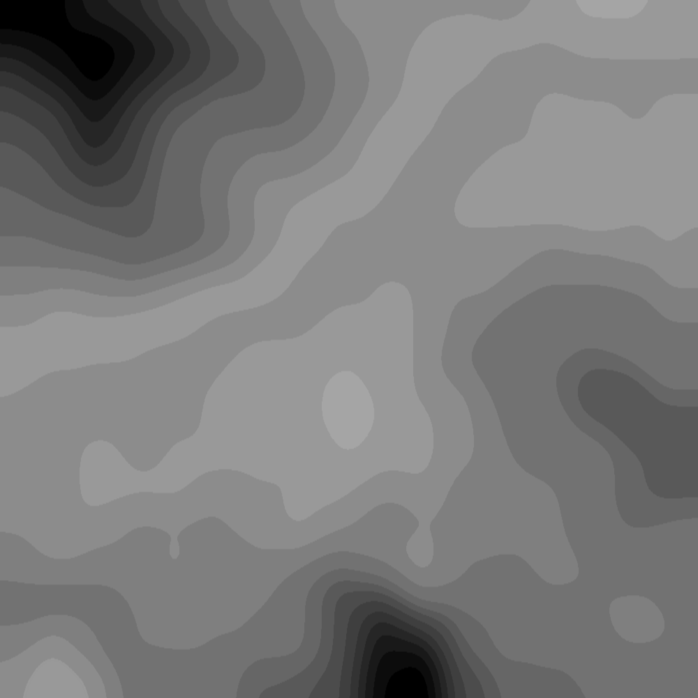
This is what I get after some tinkering in paint.net. When this is loaded into MMaker it gets pixalated but no problem as I have already finished playing with the greyscale. I have the terrain map as a layer so that I can line up any features on the map to the height map. Way easier to see and make sense of. Now as stated, my elevations are rough as I am using shades that are about 10 notches lighter with each elevation change. MMaker will pixelate it and I will be able to smooth inside MMaker, but this is all that needs to be done.

(in reply to rickier65)
Post #: 30
Page:   [1] 2   next >   >>
All Forums >> [Current Games From Matrix.] >> [World War II] >> Panzer Command: Ostfront >> Panzer War Miniature Rules Page: [1] 2   next >   >>
Jump to:


New Messages No New Messages
Hot Topic w/ New Messages Hot Topic w/o New Messages
Locked w/ New Messages Locked w/o New Messages
 Post New Thread
 Reply to Message
 Post New Poll
 Submit Vote
 Delete My Own Post
 Delete My Own Thread
 Rate Posts


Forum Software © ASPPlayground.NET Advanced Edition 2.4.5 ANSI

1.234