Matrix Games Forums

Forums  Register  Login  Photo Gallery  Member List  Search  Calendars  FAQ 

My Profile  Inbox  Address Book  My Subscription  My Forums  Log Out

RE: Modifications to MWiF Scandinavia Map portion

 
View related threads: (in this forum | in all forums)

Logged in as: Guest
Users viewing this topic: none
  Printable Version
All Forums >> [New Releases from Matrix Games] >> World in Flames >> RE: Modifications to MWiF Scandinavia Map portion Page: <<   < prev  10 11 [12] 13 14   next >   >>
Login
Message << Older Topic   Newer Topic >>
RE: Modifications to MWiF Scandinavia Map portion - 10/7/2006 2:18:41 AM   
Toed


Posts: 55
Joined: 8/5/2006
From: Sweden
Status: offline
You asked for picky so here is it

5. The port of Sundsvall should be moved to the north inside its hex so that is adjacent to Indalsälven. It is actually somthing like 6 km from the actual rivermouth but considering the scale we're working it looks better closer to the river imo.

(in reply to Froonp)
Post #: 331
RE: Modifications to MWiF Scandinavia Map portion - 10/7/2006 3:09:22 AM   
Shannon V. OKeets


Posts: 22095
Joined: 5/19/2005
From: Honolulu, Hawaii
Status: offline

quote:

ORIGINAL: Incy

For the black hexsides at sea problem, it would be very nice if it would be possible to make all all-sea hexsides blue, and all all land and mixed hexides black.
This would really facilitate identification of invadable hexes, and I think it would look good too.

Incy

No. We had this discussion before. The arguments for and against this were listed then - somewhere. My decision was then, and now, is no.

I'll remove the black lines from the coastal hexes.

_____________________________

Steve

Perfection is an elusive goal.

(in reply to Incy)
Post #: 332
RE: Modifications to MWiF Scandinavia Map portion - 10/7/2006 3:15:29 AM   
Shannon V. OKeets


Posts: 22095
Joined: 5/19/2005
From: Honolulu, Hawaii
Status: offline

quote:

ORIGINAL: Incy

The same arrangement would also help players figure out all-sea lake hexides. Many hexes have very ambigous graphics.
Hornavatn and Storsjön for instance are not lakes at all as drawn(by the rulebook).
I think many players would interpret them as all-lake hexides, though. But a rule lawyer would rightly argue they're not.

You are right that the graphics for those 2 lake hexsides have to be improved. They should overlie the hexside so that the entire black line separating the hexes is surrounded by blue. Running through the middle off the hex, close to the hexside, sort of works for rivers, but fails for the lakes. If you see other lake hexsides like that, please point them out.

_____________________________

Steve

Perfection is an elusive goal.

(in reply to Incy)
Post #: 333
RE: Modifications to MWiF Scandinavia Map portion - 10/7/2006 4:01:13 AM   
Incy


Posts: 336
Joined: 10/25/2003
Status: offline
-Mjøsa? (lower left corner)
-Store Lulevatten
-Hexes NE and NW of Trondheim
-Lofoten (islands 3 and 4 hexes west of Narvik) (but add 1-2 straits in Lofoten?) (also a name for the group of island would be nice. The SW part is called Lofoten, the NE part is called Vesterålen)


quote:

ORIGINAL: Shannon V. OKeets


quote:

ORIGINAL: Incy

The same arrangement would also help players figure out all-sea lake hexides. Many hexes have very ambigous graphics.
Hornavatn and Storsjön for instance are not lakes at all as drawn(by the rulebook).
I think many players would interpret them as all-lake hexides, though. But a rule lawyer would rightly argue they're not.

You are right that the graphics for those 2 lake hexsides have to be improved. They should overlie the hexside so that the entire black line separating the hexes is surrounded by blue. Running through the middle off the hex, close to the hexside, sort of works for rivers, but fails for the lakes. If you see other lake hexsides like that, please point them out.


(in reply to Shannon V. OKeets)
Post #: 334
RE: Modifications to MWiF Scandinavia Map portion - 10/7/2006 4:09:07 AM   
Incy


Posts: 336
Joined: 10/25/2003
Status: offline
Names for the arctic ilands should be changed.

"bear island" is english. "Bjørnøya" in norwegian.
"Spitzbergen" is german. "Svalbard" in norwegian. (The main island of the archipelagio is called spitsbergen (with S, not Z))

The map for Svarlbard is quite poor, for better map and proper names, see:


< Message edited by Incy -- 10/7/2006 4:17:28 AM >

(in reply to Incy)
Post #: 335
RE: Modifications to MWiF Scandinavia Map portion - 10/7/2006 4:13:03 AM   
Incy


Posts: 336
Joined: 10/25/2003
Status: offline
-2 sea borders (nort sea<->norwegian, north sea<->baltic) dont connect all the way to shore
-Svalbard should have several glacier hexes, not only tundra (se map in previous post)

< Message edited by Incy -- 10/7/2006 4:34:21 AM >

(in reply to Incy)
Post #: 336
RE: Modifications to MWiF Scandinavia Map portion - 10/7/2006 4:33:00 AM   
Shannon V. OKeets


Posts: 22095
Joined: 5/19/2005
From: Honolulu, Hawaii
Status: offline

quote:

ORIGINAL: Incy

-2 sea borders dont connect all the way to shore
-Svalbard should have several glacier hexes, not only tundra (se map in previous post)

Thanks, changing terrain is trivial. But looking at that map ... Brrrr.

_____________________________

Steve

Perfection is an elusive goal.

(in reply to Incy)
Post #: 337
RE: Modifications to MWiF Scandinavia Map portion - 10/7/2006 4:35:36 AM   
Shannon V. OKeets


Posts: 22095
Joined: 5/19/2005
From: Honolulu, Hawaii
Status: offline
Here is the coast line without those annoying black hexgrid lines.

Patrice, about the river that goes nowhere, perhaps it should have a little tail instead of ending sharply at the hex boundary?


Attachment (1)

_____________________________

Steve

Perfection is an elusive goal.

(in reply to Shannon V. OKeets)
Post #: 338
RE: Modifications to MWiF Scandinavia Map portion - 10/7/2006 11:30:12 AM   
Froonp


Posts: 7995
Joined: 10/21/2003
From: Marseilles, France
Status: offline
quote:

ORIGINAL: Incy
For the black hexsides at sea problem, it would be very nice if it would be possible to make all all-sea hexsides blue, and all all land and mixed hexides black.
This would really facilitate identification of invadable hexes, and I think it would look good too.

Incy

I agree. Good idea.

(in reply to Incy)
Post #: 339
RE: Modifications to MWiF Scandinavia Map portion - 10/7/2006 11:30:59 AM   
Froonp


Posts: 7995
Joined: 10/21/2003
From: Marseilles, France
Status: offline
quote:

ORIGINAL: Incy

The same arrangement would also help players figure out all-sea lake hexides. Many hexes have very ambigous graphics.
Hornavatn and Storsjön for instance are not lakes at all as drawn(by the rulebook).
I think many players would interpret them as all-lake hexides, though. But a rule lawyer would rightly argue they're not.

Good idea too !!!
I hope this is doable.

(in reply to Incy)
Post #: 340
RE: Modifications to MWiF Scandinavia Map portion - 10/7/2006 11:39:28 AM   
Froonp


Posts: 7995
Joined: 10/21/2003
From: Marseilles, France
Status: offline
quote:

-Hexes NE and NW of Trondheim

Yes, there is a bit of land from hex NE Trondheim that enters hex NW, this was not intended.

quote:

-Lofoten (islands 3 and 4 hexes west of Narvik) (but add 1-2 straits in Lofoten?) (also a name for the group of island would be nice. The SW part is called Lofoten, the NE part is called Vesterålen)

Having the middle island of the Lofoten Islands being a 2 hex island was intended. That's why I drew them across the hex boundary on purpose. There is no all sea hexside between both hexes. Maybe the islands are so close here that it is not necessary to change.
Also I intended to add the "Lofoten Islands" label, would it be sufficient ?

(in reply to Incy)
Post #: 341
RE: Modifications to MWiF Scandinavia Map portion - 10/7/2006 11:49:41 AM   
Froonp


Posts: 7995
Joined: 10/21/2003
From: Marseilles, France
Status: offline
quote:

ORIGINAL: Incy

Names for the arctic ilands should be changed.

"bear island" is english. "Bjørnøya" in norwegian.
"Spitzbergen" is german. "Svalbard" in norwegian. (The main island of the archipelagio is called spitsbergen (with S, not Z))

Didn't we say that we were not using local names, but rather international names ? Can't really remember
Anyway, you must know that at start, this place was named Spitsbergen (with an S) and that I changed it to Spitzbergen (with a Z) because I saw that written this way in all books and stories about WWII.
The Oxford Companion to WWII even have a list of place that had a wartime name and a current name, and it says that the wartime name was Spitzbergen, and the Current name is Spitsbergen.
So I propose to keep Spitzbergen.
For Bear Island, it is named on the map this way from the start, I did not touch it.
When you look at WWII maps of the area, you find it named Bear Island (Oxford Companion to WWII page 36-37 for example).

quote:

The map for Svarlbard is quite poor, for better map and proper names, see:

I had made other outlines for the coastlines here, but Rob made his own before I had a chance to send him mines.

(in reply to Incy)
Post #: 342
RE: Modifications to MWiF Scandinavia Map portion - 10/7/2006 11:54:53 AM   
Froonp


Posts: 7995
Joined: 10/21/2003
From: Marseilles, France
Status: offline
quote:

Names for the arctic ilands should be changed.
"bear island" is english. "Bjørnøya" in norwegian.
"Spitzbergen" is german. "Svalbard" in norwegian. (The main island of the archipelagio is called spitsbergen (with S, not Z))

The Oxford Companion to WWII has it that Spitzbergen is the wartime name, and Spitsbergen is the current name.
Same for Bear Islands, WWII maps of the area have it named Bear Island (Oxford Companion to WWII p.36-37)

quote:

The map for Svarlbard is quite poor, for better map and proper names, see:

I had made another drawing of this place, but Rob drew its own before I sent him mine.

EDIT : Sorry for the double post, I thought that my first post was lost, so retyped it, shorter, a second time.

< Message edited by Froonp -- 10/7/2006 11:57:52 AM >

(in reply to Incy)
Post #: 343
RE: Modifications to MWiF Scandinavia Map portion - 10/7/2006 2:00:16 PM   
Froonp


Posts: 7995
Joined: 10/21/2003
From: Marseilles, France
Status: offline
quote:

ORIGINAL: Incy
The map for Svarlbard is quite poor, for better map and proper names, see:

You must consider that the area depicted on MWiF map is only the area south of the 78th Parallel (guess-estimation).
So with this in mind, I now think that Rob's depiction is not that bad. It is even superior to mine IMO.

(in reply to Incy)
Post #: 344
RE: Modifications to MWiF Scandinavia Map portion - 10/7/2006 2:01:39 PM   
Froonp


Posts: 7995
Joined: 10/21/2003
From: Marseilles, France
Status: offline
quote:

-2 sea borders (nort sea<->norwegian, north sea<->baltic) dont connect all the way to shore

They bisect the hex, which is sufficient. They do not need to run up to the land drawn.

(in reply to Incy)
Post #: 345
RE: Modifications to MWiF Scandinavia Map portion - 10/7/2006 2:02:40 PM   
Froonp


Posts: 7995
Joined: 10/21/2003
From: Marseilles, France
Status: offline
quote:

ORIGINAL: Incy
-Svalbard should have several glacier hexes, not only tundra (se map in previous post)

Given that the area depicted on MWiF map is only the area south of the 78th Parallel (guess-estimation), what hexes should be changed in your opinion ?

(in reply to Incy)
Post #: 346
RE: Modifications to MWiF Scandinavia Map portion - 10/7/2006 2:07:35 PM   
Froonp


Posts: 7995
Joined: 10/21/2003
From: Marseilles, France
Status: offline
quote:

ORIGINAL: Shannon V. OKeets
Here is the coast line without those annoying black hexgrid lines.

This single detail changes it all. Now it is a marvel, you'd even wish you could bath here .

quote:

Patrice, about the river that goes nowhere, perhaps it should have a little tail instead of ending sharply at the hex boundary?

I'm adding this hex into the RLS file.
If Rob drew a tail for it, it will show on the map.

(in reply to Shannon V. OKeets)
Post #: 347
RE: Modifications to MWiF Scandinavia Map portion - 10/7/2006 9:02:06 PM   
Shannon V. OKeets


Posts: 22095
Joined: 5/19/2005
From: Honolulu, Hawaii
Status: offline

quote:

ORIGINAL: Froonp

quote:

ORIGINAL: Shannon V. OKeets
Here is the coast line without those annoying black hexgrid lines.

This single detail changes it all. Now it is a marvel, you'd even wish you could bath here .

quote:

Patrice, about the river that goes nowhere, perhaps it should have a little tail instead of ending sharply at the hex boundary?

I'm adding this hex into the RLS file.
If Rob drew a tail for it, it will show on the map.

Thanks.

_____________________________

Steve

Perfection is an elusive goal.

(in reply to Froonp)
Post #: 348
RE: Modifications to MWiF Scandinavia Map portion - 10/8/2006 1:00:17 AM   
Incy


Posts: 336
Joined: 10/25/2003
Status: offline
Now that i know everything north of the 78 isn't there, it does look a lot better.
Placing the glaciers properly isn't easy. Maybe one on Edgeøya (the eastern island), and one on the easternmost hex on Spitsbergen ?
The island "Hopen" could also be added (2 hexes SE of Edgeøya).
It's small, but is well suited as a base, and is the only island other than Spitsbergen (and Bjørnøya) with a permanent settlement.
Hopen station was built 1945 (meterological & later helicopter)
Spitsbergen has had permanent settlement since 1906, several thousand people live there(mostly russians and norwegians).
It's the only place in the world (as far as I know of) where it's mandatory for kindergarten teachers to always carry a big, loaded heavy caliber gun.
It's also one of those rare places on earth completely without immigration restrictions, if you can get there (and support yourself) you are welcome to stay (if you are willing).

Germany had several meterological stations on Svalbard during WWII, and the allies occationaly sent troops there to try to track down the german stations. Same thing on the greenland east coast, I believe. Anyways, you guys all know that, all you have to do is look at the cover box of your favourite WW2 game and you see the Svalbard and Greenland bases.

quote:

ORIGINAL: Froonp

quote:

ORIGINAL: Incy
-Svalbard should have several glacier hexes, not only tundra (se map in previous post)

Given that the area depicted on MWiF map is only the area south of the 78th Parallel (guess-estimation), what hexes should be changed in your opinion ?


(in reply to Froonp)
Post #: 349
RE: Modifications to MWiF Scandinavia Map portion - 10/8/2006 1:11:42 AM   
Incy


Posts: 336
Joined: 10/25/2003
Status: offline
Am I right that you draw hexes one hexrow at a time from left to right starting from the top? And that each border is drawn twice, so the color of the hexside is that of the last drawn hex? Sometimes all-land hexsides are blue, and sometimes black, and it doesn't seem consistrant.
(but it's not really annoying so I suggest you dont spend time fixing it)

If there is an easy fix for the lake hexsides, please consider dointg them too (Could the lake bitmaps be laid over the hex borders and have the hexides as part of the bitmaps?)

(in reply to Shannon V. OKeets)
Post #: 350
RE: Modifications to MWiF Scandinavia Map portion - 10/8/2006 1:43:35 AM   
Shannon V. OKeets


Posts: 22095
Joined: 5/19/2005
From: Honolulu, Hawaii
Status: offline
quote:

ORIGINAL: Incy
Am I right that you draw hexes one hexrow at a time from left to right starting from the top? And that each border is drawn twice, so the color of the hexside is that of the last drawn hex? Sometimes all-land hexsides are blue, and sometimes black, and it doesn't seem consistrant.
(but it's not really annoying so I suggest you dont spend time fixing it)

If there is an easy fix for the lake hexsides, please consider dointg them too (Could the lake bitmaps be laid over the hex borders and have the hexides as part of the bitmaps?)


It's a little trickier than that. The processing is from left to right, top to bottom, but each hexside is drawn only once. Hexsides are drawn for only 3 of the hexsides for each hex: left and two top hexsides. That is more efficient (coded by Chris) and enables the hexsides to be drawn only 1 pixel wide when so desired.

So, the color of blue versus black is determined by: (1) whether the hex is coastal or not, and (2) whether the left/top or right/bottom hexsides are being drawn. It has nothing to do with the adjacent terrain type. The use of the blue enables the coastal hexsides to blend smoothly with the all sea hexes, removing the spurious grid line that I, and many others, found offensive.

A more comprehensive solution could be worked out based on the adjacent terrain for each hex. But that wuold require more code and take time whenever the map is redrawn - which is pretty much continuously when playing the game.

Compare Stettin with Kolberg to see this in effect.


Attachment (1)

_____________________________

Steve

Perfection is an elusive goal.

(in reply to Incy)
Post #: 351
RE: Modifications to MWiF Scandinavia Map portion - 10/8/2006 2:07:58 AM   
Froonp


Posts: 7995
Joined: 10/21/2003
From: Marseilles, France
Status: offline
quote:

A more comprehensive solution could be worked out based on the adjacent terrain for each hex. But that wuold require more code and take time whenever the map is redrawn - which is pretty much continuously when playing the game.

I would vote for the quickest redrawn time, because you scroll the map A LOT.

(in reply to Shannon V. OKeets)
Post #: 352
RE: Modifications to MWiF Scandinavia Map portion - 10/8/2006 2:14:30 AM   
Froonp


Posts: 7995
Joined: 10/21/2003
From: Marseilles, France
Status: offline
quote:

Placing the glaciers properly isn't easy. Maybe one on Edgeøya (the eastern island), and one on the easternmost hex on Spitsbergen ?

Done.

quote:

The island "Hopen" could also be added (2 hexes SE of Edgeøya).
It's small, but is well suited as a base, and is the only island other than Spitsbergen (and Bjørnøya) with a permanent settlement.
Hopen station was built 1945 (meterological & later helicopter)

Unfortunately, now that the coastlines have been drawn, this is no more possible.
But I think this is not a big deal, as I think that never a single WiF counter will go into Spitzbergen.

(in reply to Incy)
Post #: 353
RE: Modifications to MWiF Scandinavia Map portion - 10/8/2006 12:44:27 PM   
Incy


Posts: 336
Joined: 10/25/2003
Status: offline
Thanks, now I understand how they're drawn. I too agree further work on this is not worth the time and CPU cycles.
Also, now that I know the algorithm the hexsides give me all the information I wanted ;)

For instance, I think that the hex SE of Stettin should not be a coastal hex?
Also, while I'm looking over this area, that island east of Malmø (Bornholm) is danish, not swedish. It probably should have it's own hex. But then again it's on the european map, which we try not to change..


quote:

ORIGINAL: Shannon V. OKeets

quote:

ORIGINAL: Incy
Am I right that you draw hexes one hexrow at a time from left to right starting from the top? And that each border is drawn twice, so the color of the hexside is that of the last drawn hex? Sometimes all-land hexsides are blue, and sometimes black, and it doesn't seem consistrant.
(but it's not really annoying so I suggest you dont spend time fixing it)

If there is an easy fix for the lake hexsides, please consider dointg them too (Could the lake bitmaps be laid over the hex borders and have the hexides as part of the bitmaps?)


It's a little trickier than that. The processing is from left to right, top to bottom, but each hexside is drawn only once. Hexsides are drawn for only 3 of the hexsides for each hex: left and two top hexsides. That is more efficient (coded by Chris) and enables the hexsides to be drawn only 1 pixel wide when so desired.

So, the color of blue versus black is determined by: (1) whether the hex is coastal or not, and (2) whether the left/top or right/bottom hexsides are being drawn. It has nothing to do with the adjacent terrain type. The use of the blue enables the coastal hexsides to blend smoothly with the all sea hexes, removing the spurious grid line that I, and many others, found offensive.

A more comprehensive solution could be worked out based on the adjacent terrain for each hex. But that wuold require more code and take time whenever the map is redrawn - which is pretty much continuously when playing the game.

Compare Stettin with Kolberg to see this in effect.


(in reply to Shannon V. OKeets)
Post #: 354
RE: Modifications to MWiF Scandinavia Map portion - 10/8/2006 1:52:55 PM   
Froonp


Posts: 7995
Joined: 10/21/2003
From: Marseilles, France
Status: offline
quote:

For instance, I think that the hex SE of Stettin should not be a coastal hex?

It can only be a coastal hex. Given that both the E hexside of Stettin and the W hexside of the hex E of it are all sea hexside, and land movement is impossible (unless MAR) between both hexes. The shore HAS to be somewhere in between both hexes, and it is in the third hex, the one SE of Stettin.

quote:

Also, while I'm looking over this area, that island east of Malmø (Bornholm) is danish, not swedish. It probably should have it's own hex. But then again it's on the european map, which we try not to change..

The drawing cannot be changed here.

(in reply to Incy)
Post #: 355
RE: Modifications to MWiF Scandinavia Map portion - 10/8/2006 4:04:19 PM   
Neilster


Posts: 2890
Joined: 10/27/2003
From: Hobart, Tasmania, Australia
Status: offline
quote:

ORIGINAL: Shannon V. OKeets


OK, the real question is, in which hex did Mitchell Gant land the Firefox in Firefox Down?

Cheers, Neilster


Attachment (1)

< Message edited by Neilster -- 10/8/2006 5:39:36 PM >

(in reply to Shannon V. OKeets)
Post #: 356
RE: Modifications to MWiF Scandinavia Map portion - 10/9/2006 7:47:18 PM   
Incy


Posts: 336
Joined: 10/25/2003
Status: offline

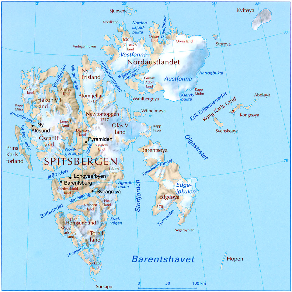
Hi, I've checked the historic names with the Svalbard museum/(ran by the Svalbard sysselmann) , and according to them the official name for the archipelago is and was Svalbard.
Also according to them, norwegian and allied forces used "Svalbard", while german forces mostly used "Spitsbergen" (I think they're wrong here, AFAIK the germans used "Spitzbergen").

They also inform me that US and UK forces used Bear Island for "Bjørnøya" (Bear Island is just a literal translation of the norwegian name).

So if local names are to be used, I think "Svalbard" and "Bjørnøya" are correct (and "Spitsbergen" + "Edgeøya" for the western and eastern islands shown)

Another island for the map should be Jan Mayen (No), which should be 1 mountain hex, located 600 km north of icland and 500 km east of Greenland.
http://en.wikipedia.org/wiki/Jan_Mayen

The main purpose if that island would of course be to make a little splotch in the middle of all that blue. The island is 55 km long and features a big volcano, and was uninhabited during WW2.

quote:

ORIGINAL: Froonp

quote:

Names for the arctic ilands should be changed.
"bear island" is english. "Bjørnøya" in norwegian.
"Spitzbergen" is german. "Svalbard" in norwegian. (The main island of the archipelagio is called spitsbergen (with S, not Z))

The Oxford Companion to WWII has it that Spitzbergen is the wartime name, and Spitsbergen is the current name.
Same for Bear Islands, WWII maps of the area have it named Bear Island (Oxford Companion to WWII p.36-37)

quote:

The map for Svarlbard is quite poor, for better map and proper names, see:

I had made another drawing of this place, but Rob drew its own before I sent him mine.

EDIT : Sorry for the double post, I thought that my first post was lost, so retyped it, shorter, a second time.


(in reply to Froonp)
Post #: 357
RE: Modifications to MWiF Scandinavia Map portion - 10/9/2006 9:19:31 PM   
Froonp


Posts: 7995
Joined: 10/21/2003
From: Marseilles, France
Status: offline
quote:

Another island for the map should be Jan Mayen (No), which should be 1 mountain hex, located 600 km north of icland and 500 km east of Greenland.
http://en.wikipedia.org/wiki/Jan_Mayen

The main purpose if that island would of course be to make a little splotch in the middle of all that blue. The island is 55 km long and features a big volcano, and was uninhabited during WW2.

Yes, this one is already on the map.
Here is it (names are semi hidden, because I didn't re write them) :


Attachment (1)

(in reply to Incy)
Post #: 358
RE: Modifications to MWiF Scandinavia Map portion - 10/9/2006 9:23:27 PM   
Froonp


Posts: 7995
Joined: 10/21/2003
From: Marseilles, France
Status: offline
In the "Freezing cold" series, there is also Greenland. Here is its southern part. There are 8 more hex rows above this picture, and then the top of the map.


Attachment (1)

(in reply to Froonp)
Post #: 359
RE: Modifications to MWiF Scandinavia Map portion - 10/9/2006 11:15:01 PM   
Jeff Gilbert


Posts: 67
Joined: 10/2/2005
Status: offline
I am continually amazed at the quality work being done on the maps for MWiF.
They are looking so good I will buy the game just for the maps!
Of course, the game would be a nice add on.

_____________________________

Jeff Gilbert
US Army [Ret]
Palm Harbor, Florida, USA

(in reply to Froonp)
Post #: 360
Page:   <<   < prev  10 11 [12] 13 14   next >   >>
All Forums >> [New Releases from Matrix Games] >> World in Flames >> RE: Modifications to MWiF Scandinavia Map portion Page: <<   < prev  10 11 [12] 13 14   next >   >>
Jump to:


New Messages No New Messages
Hot Topic w/ New Messages Hot Topic w/o New Messages
Locked w/ New Messages Locked w/o New Messages
 Post New Thread
 Reply to Message
 Post New Poll
 Submit Vote
 Delete My Own Post
 Delete My Own Thread
 Rate Posts


Forum Software © ASPPlayground.NET Advanced Edition 2.4.5 ANSI

1.156