Matrix Games Forums

Forums  Register  Login  Photo Gallery  Member List  Search  Calendars  FAQ 

My Profile  Inbox  Address Book  My Subscription  My Forums  Log Out

RE: MWiF Map Review - India & Burma

 
View related threads: (in this forum | in all forums)

Logged in as: Guest
Users viewing this topic: none
  Printable Version
All Forums >> [New Releases from Matrix Games] >> World in Flames >> RE: MWiF Map Review - India & Burma Page: <<   < prev  3 4 [5] 6 7   next >   >>
Login
Message << Older Topic   Newer Topic >>
RE: MWiF Map Review - India & Burma - 7/20/2008 4:00:40 AM   
Norman42


Posts: 244
Joined: 2/9/2008
From: Canada
Status: offline

quote:

ORIGINAL: Froonp

I say your drawing is not that bad.
What do others think ?


I like Ian's map changes.

I would also add in the change to those 2 mountain hexes closest to the Tigris (change to Desert or Clear), and change the 4 hexes in between the Tigris and Euphrates Rivers to Clear.


_____________________________

-------------

C.L.Norman

(in reply to Froonp)
Post #: 121
RE: MWiF Map Review - India & Burma - 7/20/2008 4:58:03 AM   
paulderynck


Posts: 8201
Joined: 3/24/2007
From: Canada
Status: offline

quote:

ORIGINAL: Plain Ian

Regarding Iraq if we are going to use the map picture to get a better representation of the country then I think we also have to adjust its other borders. If we use the rivers Euphrates and Tigris to guage things then I think we would need to move the borders as below?


This one looks perfect to me. (Seems to me I've been seeing various maps of Iraq in the media now for about 15 years, and this one fits the burned-in image best.)

_____________________________

Paul

(in reply to Plainian)
Post #: 122
RE: MWiF Map Review - India & Burma - 7/20/2008 9:05:22 AM   
Froonp


Posts: 7995
Joined: 10/21/2003
From: Marseilles, France
Status: offline
quote:

ORIGINAL: paulderynck
This one looks perfect to me. (Seems to me I've been seeing various maps of Iraq in the media now for about 15 years, and this one fits the burned-in image best.)

Based on all your suggestions, it would look like this :


Attachment (1)

(in reply to paulderynck)
Post #: 123
RE: MWiF Map Review - India & Burma - 7/20/2008 9:23:12 AM   
Froonp


Posts: 7995
Joined: 10/21/2003
From: Marseilles, France
Status: offline
quote:

ORIGINAL: Froonp

quote:

ORIGINAL: paulderynck
This one looks perfect to me. (Seems to me I've been seeing various maps of Iraq in the media now for about 15 years, and this one fits the burned-in image best.)

Based on all your suggestions, it would look like this :

I would not give the hex 2 hexes West of the lake to Syria. I woud leave it Iraqi (The lake looks to be about in the middle of the east-west width of Iraq).


< Message edited by Froonp -- 7/20/2008 9:24:22 AM >

(in reply to Froonp)
Post #: 124
RE: MWiF Map Review - India & Burma - 7/20/2008 10:09:47 AM   
Shannon V. OKeets


Posts: 22095
Joined: 5/19/2005
From: Honolulu, Hawaii
Status: offline

quote:

ORIGINAL: Froonp

quote:

ORIGINAL: paulderynck
This one looks perfect to me. (Seems to me I've been seeing various maps of Iraq in the media now for about 15 years, and this one fits the burned-in image best.)

Based on all your suggestions, it would look like this :


The alpine hexes would need to be removed too since they require mountains on both sides.

_____________________________

Steve

Perfection is an elusive goal.

(in reply to Froonp)
Post #: 125
RE: MWiF Map Review - India & Burma - 7/20/2008 10:18:09 AM   
Froonp


Posts: 7995
Joined: 10/21/2003
From: Marseilles, France
Status: offline
quote:

ORIGINAL: Froonp
quote:

ORIGINAL: Froonp

quote:

ORIGINAL: paulderynck
This one looks perfect to me. (Seems to me I've been seeing various maps of Iraq in the media now for about 15 years, and this one fits the burned-in image best.)

Based on all your suggestions, it would look like this :

I would not give the hex 2 hexes West of the lake to Syria. I woud leave it Iraqi (The lake looks to be about in the middle of the east-west width of Iraq).

I also looked at the big picture of the Middle East, with those modifications in mind, and it looks good. I think I'm gonna do these Iraq / Kuwait modifications to the borders and terrain.

quote:

ORIGINAL: Shannon V. OKeets
The alpine hexes would need to be removed too since they require mountains on both sides.

Yes.

< Message edited by Froonp -- 7/20/2008 10:21:17 AM >

(in reply to Shannon V. OKeets)
Post #: 126
RE: MWiF Map Review - India & Burma - 7/20/2008 1:25:19 PM   
ahlner


Posts: 15
Joined: 10/7/2006
From: Stockholm, Sweden
Status: offline
Here is another suggestion for the Iraq-Kuwaiti border which I think resembles the real border as much as possible. Just two hex changes compared to the latest map (marked with dotted lines). I would also propose two hex changes to the Trans-Jordan eastern border on Saudi-Arabia and Iraq. Trans-Jordan is in my opinion depicted a bit large compared wtih the real map borders.


Attachment (1)

(in reply to Froonp)
Post #: 127
RE: MWiF Map Review - India & Burma - 7/20/2008 3:34:09 PM   
Froonp


Posts: 7995
Joined: 10/21/2003
From: Marseilles, France
Status: offline
quote:

ORIGINAL: ahlner

Here is another suggestion for the Iraq-Kuwaiti border which I think resembles the real border as much as possible. Just two hex changes compared to the latest map (marked with dotted lines). I would also propose two hex changes to the Trans-Jordan eastern border on Saudi-Arabia and Iraq. Trans-Jordan is in my opinion depicted a bit large compared wtih the real map borders.

This is a variation of Plain Ian's proposal ? It looks like it is.

(in reply to ahlner)
Post #: 128
RE: MWiF Map Review - India & Burma - 7/20/2008 3:41:17 PM   
Froonp


Posts: 7995
Joined: 10/21/2003
From: Marseilles, France
Status: offline
quote:

ORIGINAL: ahlner

Here is another suggestion for the Iraq-Kuwaiti border which I think resembles the real border as much as possible. Just two hex changes compared to the latest map (marked with dotted lines). I would also propose two hex changes to the Trans-Jordan eastern border on Saudi-Arabia and Iraq. Trans-Jordan is in my opinion depicted a bit large compared wtih the real map borders.


I think your variation to Trans-Jordan eastern and south eastern border is not better, as we can see on this 1942 map of the Middle East. The eastern border (with Iraq) looks like a straight line more or less NW-SE slope, and the previsous depiction is better IMO. The SE border with Saudi Arabia also looks like it has a sharp angle, and your depiction shows this angle less than the original one.


Attachment (1)

(in reply to ahlner)
Post #: 129
RE: MWiF Map Review - India & Burma - 7/20/2008 3:43:50 PM   
Froonp


Posts: 7995
Joined: 10/21/2003
From: Marseilles, France
Status: offline
About this last map (Middle East 1942), I wonder what is this diamond shapped territory west of Kuwait. It show on others maps of this area during WW2.
Like this one (Oil routes in Middle East, 1941) :

Anyone knows ?


Attachment (1)

< Message edited by Froonp -- 7/20/2008 3:46:43 PM >

(in reply to Froonp)
Post #: 130
RE: MWiF Map Review - India & Burma - 7/20/2008 5:14:38 PM   
ahlner


Posts: 15
Joined: 10/7/2006
From: Stockholm, Sweden
Status: offline
OK, I only had a map with the borders of today and probably they have changed somewhat since the 1940s. I think Plain Ian's proposal is good.

(in reply to Froonp)
Post #: 131
RE: MWiF Map Review - India & Burma - 7/20/2008 5:15:40 PM   
Norman42


Posts: 244
Joined: 2/9/2008
From: Canada
Status: offline
quote:

ORIGINAL: Froonp

About this last map (Middle East 1942), I wonder what is this diamond shapped territory west of Kuwait. It show on others maps of this area during WW2.
Like this one (Oil routes in Middle East, 1941) :

Anyone knows ?


I believe thats the 'disputed area'. Undefined border between Iraq and SA that wasn't settled til the 50's if I remember my history right. There were a few of these 'bubbles' on their mutual border. There were some on SA's border with Oman and Yemen too.

< Message edited by Norman42 -- 7/20/2008 5:19:16 PM >


_____________________________

-------------

C.L.Norman

(in reply to Froonp)
Post #: 132
RE: MWiF Map Review - India & Burma - 7/20/2008 5:19:04 PM   
Froonp


Posts: 7995
Joined: 10/21/2003
From: Marseilles, France
Status: offline
quote:

ORIGINAL: Norman42
quote:

ORIGINAL: Froonp

About this last map (Middle East 1942), I wonder what is this diamond shapped territory west of Kuwait. It show on others maps of this area during WW2.
Like this one (Oil routes in Middle East, 1941) :

Anyone knows ?


I believe thats the 'disputed area'. Undefined border between Iraq and SA that wasn't settled til the 50's if I remember my history right. There were a few of these 'bubbles' on their mutual border.

My Collier Atlas name this area : "Neutral Zone" or "Neutral Area" something like that. Must be what you say.

(in reply to Norman42)
Post #: 133
RE: MWiF Map Review - India & Burma - 7/20/2008 5:20:43 PM   
Froonp


Posts: 7995
Joined: 10/21/2003
From: Marseilles, France
Status: offline
quote:

ORIGINAL: marcuswatney

Mecca is not on the coast.  The name of the port there is Jeddah.

I'll correct that.

(in reply to marcuswatney)
Post #: 134
RE: MWiF Map Review - India & Burma - 7/20/2008 5:29:44 PM   
Froonp


Posts: 7995
Joined: 10/21/2003
From: Marseilles, France
Status: offline
quote:

ORIGINAL: marcuswatney
In the debate over Burma's oil, I think we agreed to leave the terrain and resource symbol where they are, but change the name from Yenanguang to Chauk (spelling?), as Yenanguang is actually down near where the word Irrawaddy is.

I don't remember we agreed on that.
Yenangyaung is the right place for oil : http://en.wikipedia.org/wiki/Yenangyaung.
Both Chauk and Yenangyaung are in the Magway Division, they are not that far away one from the other as this map from 1972 shows :
I'll put the Yenangyaung label more to the south (to the south of the Oil resource) and move the Akyab label a little north, and it will look better.


Attachment (1)

(in reply to marcuswatney)
Post #: 135
RE: MWiF Map Review - India & Burma - 7/20/2008 5:41:49 PM   
Froonp


Posts: 7995
Joined: 10/21/2003
From: Marseilles, France
Status: offline
quote:

ORIGINAL: Froonp

quote:

ORIGINAL: marcuswatney

Mecca is not on the coast.  The name of the port there is Jeddah.

I'll correct that.

Also, I see that this will also necessitate to push that port 1 hex NW. I'll wait 'till the 15 August modifications, because it may invalidate saved games.

(in reply to Froonp)
Post #: 136
RE: MWiF Map Review - India & Burma - 7/20/2008 5:51:47 PM   
Froonp


Posts: 7995
Joined: 10/21/2003
From: Marseilles, France
Status: offline
quote:

ORIGINAL: Froonp
quote:

ORIGINAL: marcuswatney
In the debate over Burma's oil, I think we agreed to leave the terrain and resource symbol where they are, but change the name from Yenanguang to Chauk (spelling?), as Yenanguang is actually down near where the word Irrawaddy is.

I don't remember we agreed on that.
Yenangyaung is the right place for oil : http://en.wikipedia.org/wiki/Yenangyaung.
Both Chauk and Yenangyaung are in the Magway Division, they are not that far away one from the other as this map from 1972 shows :
I'll put the Yenangyaung label more to the south (to the south of the Oil resource) and move the Akyab label a little north, and it will look better.

I remember also telling you that the oil resource was already sufficiently southward, and that I was reluctant to have it more to the south (as compared to the WiF FE maps where the oil resource is completely mistplaced in the northern mountains). Because the whole area south and north of this place had oil, I prefered to have the oil resource the most northwards possible to make the Japanese need to go north to get the oil.

(in reply to Froonp)
Post #: 137
RE: MWiF Map Review - India & Burma - 7/20/2008 8:00:11 PM   
cockney


Posts: 83
Joined: 11/15/2006
From: London
Status: offline
"Neutral Zone"

any chance of a Klingon incursion?

[image][/image]

_____________________________

never piss off a sgt major

(in reply to Froonp)
Post #: 138
RE: MWiF Map Review - India & Burma - 7/31/2008 3:32:16 AM   
Shannon V. OKeets


Posts: 22095
Joined: 5/19/2005
From: Honolulu, Hawaii
Status: offline
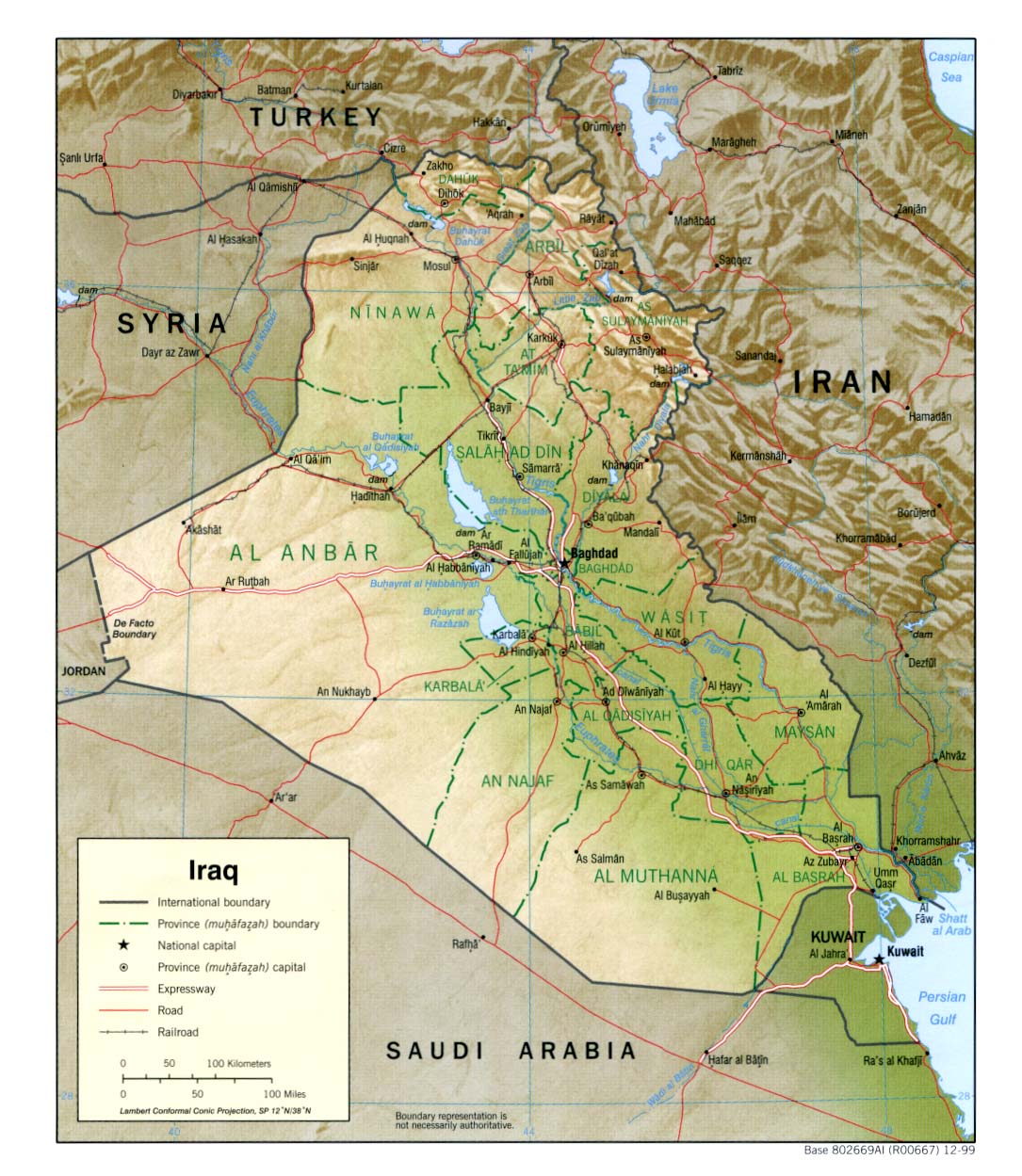
Here is a screen shot of Iraq after the discussed changes. The data was modified by Patrice and this is part of version 10.00, which I am about to upload.


Attachment (1)

_____________________________

Steve

Perfection is an elusive goal.

(in reply to cockney)
Post #: 139
RE: MWiF Map Review - India & Burma - 8/1/2008 11:48:34 PM   
Incy


Posts: 336
Joined: 10/25/2003
Status: offline
I still think Jordan is to large, and Iraq certainly does not reach far enough west.
Just compare distances between east med shore<->iraq/jordan border<->
and iraq/jordan border<-> Baghdad

I suggest Syria give hex 2W of lake Tharthar iraqi. Transjordan gives 2 eastermost hexes to Iraq. Transjordan give SE corner + hex north of that to saudi.

(in reply to Shannon V. OKeets)
Post #: 140
RE: MWiF Map Review - India & Burma - 8/1/2008 11:56:35 PM   
Incy


Posts: 336
Joined: 10/25/2003
Status: offline
Also, in respect of history, could we put Babylon on the map as a white text? It would be nice to remind people that Iraq has more than the familiar names we keep reading about in the news.

(in reply to Incy)
Post #: 141
RE: MWiF Map Review - India & Burma - 8/2/2008 7:02:18 AM   
Froonp


Posts: 7995
Joined: 10/21/2003
From: Marseilles, France
Status: offline
quote:

ORIGINAL: Incy

I still think Jordan is to large, and Iraq certainly does not reach far enough west.
Just compare distances between east med shore<->iraq/jordan border<->
and iraq/jordan border<-> Baghdad

I suggest Syria give hex 2W of lake Tharthar iraqi. Transjordan gives 2 eastermost hexes to Iraq. Transjordan give SE corner + hex north of that to saudi.

From what I see on map in post #129, the distance East Med shore <-> Iraq / Jordan border is about equal to the distance and Iraq / Jordan border <-> Baghdad, which is quite the way it is on the MWiF map (a little more than 5 hex for the first, a little less than 5 hex for the second.
Prefering to keep the modifications minimal from the WiF FE European Map, I think that we can stay that way.

quote:

ORIGINAL: Incy

Also, in respect of history, could we put Babylon on the map as a white text? It would be nice to remind people that Iraq has more than the familiar names we keep reading about in the news.

Good idea . A lot of people wil say that this is not WW2 related, but it will be size (only seen in high levels of zoom), like Troy & Persepolis (and others) already.
I will add a "Mesopotamia" region name to (in white, as for Zagros Mts & Sinai).

(in reply to Incy)
Post #: 142
RE: MWiF Map Review - India & Burma - 1/24/2009 4:44:39 PM   
Crusss Daddy


Posts: 2
Joined: 1/24/2009
Status: offline
At Euro scale, India map allows gamey Japanese tactic of DOWing Portugal in order to seize Goa & Damian, from there to stack armies at leisure for overland attack into India. Should any invasion onto subcontinent, regardless of jurisdiction, be viewed as a DOW against CW?

(in reply to Norman42)
Post #: 143
RE: MWiF Map Review - India & Burma - 1/24/2009 4:57:04 PM   
Shannon V. OKeets


Posts: 22095
Joined: 5/19/2005
From: Honolulu, Hawaii
Status: offline

quote:

ORIGINAL: Crusss Daddy

At Euro scale, India map allows gamey Japanese tactic of DOWing Portugal in order to seize Goa & Damian, from there to stack armies at leisure for overland attack into India. Should any invasion onto subcontinent, regardless of jurisdiction, be viewed as a DOW against CW?


Welcome to the forum.

I let Patrice handle the map questions, though everyone chips in their opinion when they have one.

_____________________________

Steve

Perfection is an elusive goal.

(in reply to Crusss Daddy)
Post #: 144
RE: MWiF Map Review - India & Burma - 1/24/2009 5:35:02 PM   
Froonp


Posts: 7995
Joined: 10/21/2003
From: Marseilles, France
Status: offline

quote:

ORIGINAL: Crusss Daddy

At Euro scale, India map allows gamey Japanese tactic of DOWing Portugal in order to seize Goa & Damian, from there to stack armies at leisure for overland attack into India. Should any invasion onto subcontinent, regardless of jurisdiction, be viewed as a DOW against CW?


This is the reason why I refused to make Goa or Damian minor ports, even if they would have deservec that, and also why there is no railway going to Damian & Goa.

So this is a valid strategy for Japan to DoW Portugal to seize these places, but as the CW I think I would welcome that, more than a Japanese invasion of Cocanada. The reasons why are :
- As writen above, Goa & Damian hardly allow for an army to "stack armies at leisure", or to put them in supply from the sea.
- This is harder for the Japanese to keep supply open up to the Arabian Sea, harder than just the Bay of Bengal.
- This allows the CW to control Portugal and its valuable RP.
- This hands the Acores to the CW, that will base Sunderlands there immediately for an immediate stop of the Battle of the Atlantic.
- The CW usualy have Garrisons in Bombay, for antipartisan duties, so there should be a quick way to bottle the Japs in Damian.
- An invasion of Cocanada would be better, and could target 3 RP and 1 red factories quickly, while an invasion of Damian & Goa can target nearly nothing.

So the original designers of the CWiF map had decided to add Damian, Goa & Pondycherry to India, and MAcao to China, and I liked this and found no good reason to remove them.

(in reply to Crusss Daddy)
Post #: 145
RE: MWiF Map Review - India & Burma - 1/25/2009 3:17:15 AM   
brian brian


Posts: 3191
Joined: 11/16/2005
Status: offline
Goa is a port and that is that. Wikipedia calls it "one of the finest harbors in south-east Asia". Gameyness should be fixed in the rules, not on the map. Japan doesn't have the army needed to campaign from the west coast of India and ever get anywhere, so you might as well make it a port. As the CW I'd rather see the Japanese start out there surrounded by mountains than some other possible landing areas, and the Japanese are more likely to land in the east where it is easier to deploy land-based air and protect their supply lines and actually get to something valuable like a red factory and/or some resource hexes connected to ports. Besides, India is now too huge of a target for the Japanese army to run around in, they would just get lost on the way to Dehli with huge flanks they would be unable to protect. Pondicherry and Damian don't seem anywhere near as similar, port-wise. If the CW wants to DoW Portugal, they can easily assign a unit to take Goa in case the Japanese align it. If the Japanese want to enter India via a DoW on Portugal, I'm sure the Germans would want to wring their necks for that and as the CW I'd be grateful.

If it's gamey for Japan to use Goa like that, how gamey will it be for the Allies to use Macao, a 15 square kilometer island now occupying an entire hex? Also a port. The CW can't garrison Hong Kong, but they could DoW Portugal to get the Azores and drop a garrison on Macao to annoy the Japanese....or later in the war take Portugal and simultaneously land in Macao to get a free port on the South China Sea. I'm sorry Patrice, but I feel pretty strongly about that and can't agree with treating those two tiny colonies so very differently and I see no logic in trying to fix gamey rules via heavy-handed map editing. You have done such an excellent job on everything and I know you wouldn't change basic hex terrain of clear or mountain to favor one side or the other, the terrain is the terrain, so why should ports be any different? Goa is a red herring, let the players fall into that if they want; as you note yourself elsewhere is better anyway.

I guess since it's last call on the map I'd put my two cents in again. If I hadn't just had a couple three beers I'd probably delete this and forget about it again.

(in reply to Froonp)
Post #: 146
RE: MWiF Map Review - India & Burma - 1/25/2009 3:01:03 PM   
Anendrue


Posts: 817
Joined: 7/8/2005
Status: offline
I have to agree the quality of a players "play" should be their decision not the map designer. Provided it does not allow for impossible realities. Improbable is just fine. Why else did Eisenhower pick Normandy after all it was a "gamey" chance. He even prepared a speech in case of its failure where he would assume the blame. The geographical reality of the world was just that. This is just additional possibilities the commanders had to deal with. Allow the ports to be on the map.

_____________________________

Integrity is what you do when nobody is watching.

(in reply to brian brian)
Post #: 147
RE: MWiF Map Review - India & Burma - 1/25/2009 3:51:09 PM   
Orm


Posts: 22154
Joined: 5/3/2008
From: Sweden
Status: offline
I like the map change to european scale. This does make for a change in gameplay that the original creators of WiF never considered. I am sure that the US had reacted strongly on a Japanese declaration of war on Portugal and an invasion on Portugese part of India.

quote:

This is the reason why I refused to make Goa or Damian minor ports, even if they would have deservec that, and also why there is no railway going to Damian & Goa.


Would it be possible to put port and/or railway in Goa or Damia if they had so in 1939?

Since Portugal now has some real interesting territories in the pacific a new US Entry Action for "Japan declares war on Portugal" seems needed.

Maybe this should wait for MWiF product 2?

-Orm

< Message edited by Orm -- 1/25/2009 4:08:24 PM >

(in reply to Anendrue)
Post #: 148
RE: MWiF Map Review - India & Burma - 1/25/2009 7:00:24 PM   
Froonp


Posts: 7995
Joined: 10/21/2003
From: Marseilles, France
Status: offline
quote:

ORIGINAL: brian brian

Goa is a port and that is that. Wikipedia calls it "one of the finest harbors in south-east Asia". Gameyness should be fixed in the rules, not on the map. Japan doesn't have the army needed to campaign from the west coast of India and ever get anywhere, so you might as well make it a port. As the CW I'd rather see the Japanese start out there surrounded by mountains than some other possible landing areas, and the Japanese are more likely to land in the east where it is easier to deploy land-based air and protect their supply lines and actually get to something valuable like a red factory and/or some resource hexes connected to ports. Besides, India is now too huge of a target for the Japanese army to run around in, they would just get lost on the way to Dehli with huge flanks they would be unable to protect. Pondicherry and Damian don't seem anywhere near as similar, port-wise. If the CW wants to DoW Portugal, they can easily assign a unit to take Goa in case the Japanese align it. If the Japanese want to enter India via a DoW on Portugal, I'm sure the Germans would want to wring their necks for that and as the CW I'd be grateful.

If it's gamey for Japan to use Goa like that, how gamey will it be for the Allies to use Macao, a 15 square kilometer island now occupying an entire hex? Also a port. The CW can't garrison Hong Kong, but they could DoW Portugal to get the Azores and drop a garrison on Macao to annoy the Japanese....or later in the war take Portugal and simultaneously land in Macao to get a free port on the South China Sea. I'm sorry Patrice, but I feel pretty strongly about that and can't agree with treating those two tiny colonies so very differently and I see no logic in trying to fix gamey rules via heavy-handed map editing. You have done such an excellent job on everything and I know you wouldn't change basic hex terrain of clear or mountain to favor one side or the other, the terrain is the terrain, so why should ports be any different? Goa is a red herring, let the players fall into that if they want; as you note yourself elsewhere is better anyway.

I guess since it's last call on the map I'd put my two cents in again. If I hadn't just had a couple three beers I'd probably delete this and forget about it again.

This is a so much important matter in my opinion, that I prefered to leave it as the original CWiF map designers made it. Goa, Damian and MAcao are all from CWiF. ADG was part of the original CWiF map design, and I found out during my long work with the map that they did good things. When in doubt, I always kept the things as they had designed them that's why I think that here this should stay that way.

(in reply to brian brian)
Post #: 149
RE: MWiF Map Review - India & Burma - 1/25/2009 7:01:02 PM   
Froonp


Posts: 7995
Joined: 10/21/2003
From: Marseilles, France
Status: offline
quote:

ORIGINAL: Orm
Since Portugal now has some real interesting territories in the pacific a new US Entry Action for "Japan declares war on Portugal" seems needed.

Maybe this should wait for MWiF product 2?

Very good idea IMO.

(in reply to Orm)
Post #: 150
Page:   <<   < prev  3 4 [5] 6 7   next >   >>
All Forums >> [New Releases from Matrix Games] >> World in Flames >> RE: MWiF Map Review - India & Burma Page: <<   < prev  3 4 [5] 6 7   next >   >>
Jump to:


New Messages No New Messages
Hot Topic w/ New Messages Hot Topic w/o New Messages
Locked w/ New Messages Locked w/o New Messages
 Post New Thread
 Reply to Message
 Post New Poll
 Submit Vote
 Delete My Own Post
 Delete My Own Thread
 Rate Posts


Forum Software © ASPPlayground.NET Advanced Edition 2.4.5 ANSI

1.219